Home
New Employment Site Allocations
New Employment Site Allocations
We consulted on a draft local plan from November 2023 to December 2024 that referred to employment sites. At that stage we suggested possible policy wording and showed some sites on maps but we have now identified some extra, new sites. These would be allocated in addition to the sites we have published previously. We are now consulting on:
- New employment site allocations
In considering these we would encourage you to look at the Draft East Devon Local Plan as this sets out the context for the policy and also to read our background technical papers:
- Economic Development Needs Assessment (EDNA)
- Role and Function of Settlements Study (including the site assessment methodology)
We propose to identify sites for employment use only, to ensure we have enough land for jobs close to where people live and work. On these sites we would allow industrial and business uses, storage and distribution. This will enable new businesses to find premises and existing businesses to have space to expand as well as encouraging investment in high value jobs that will increase skills and wages.
We propose that other types of development are only permitted within these areas if they will directly support the employment use and encourage investment.
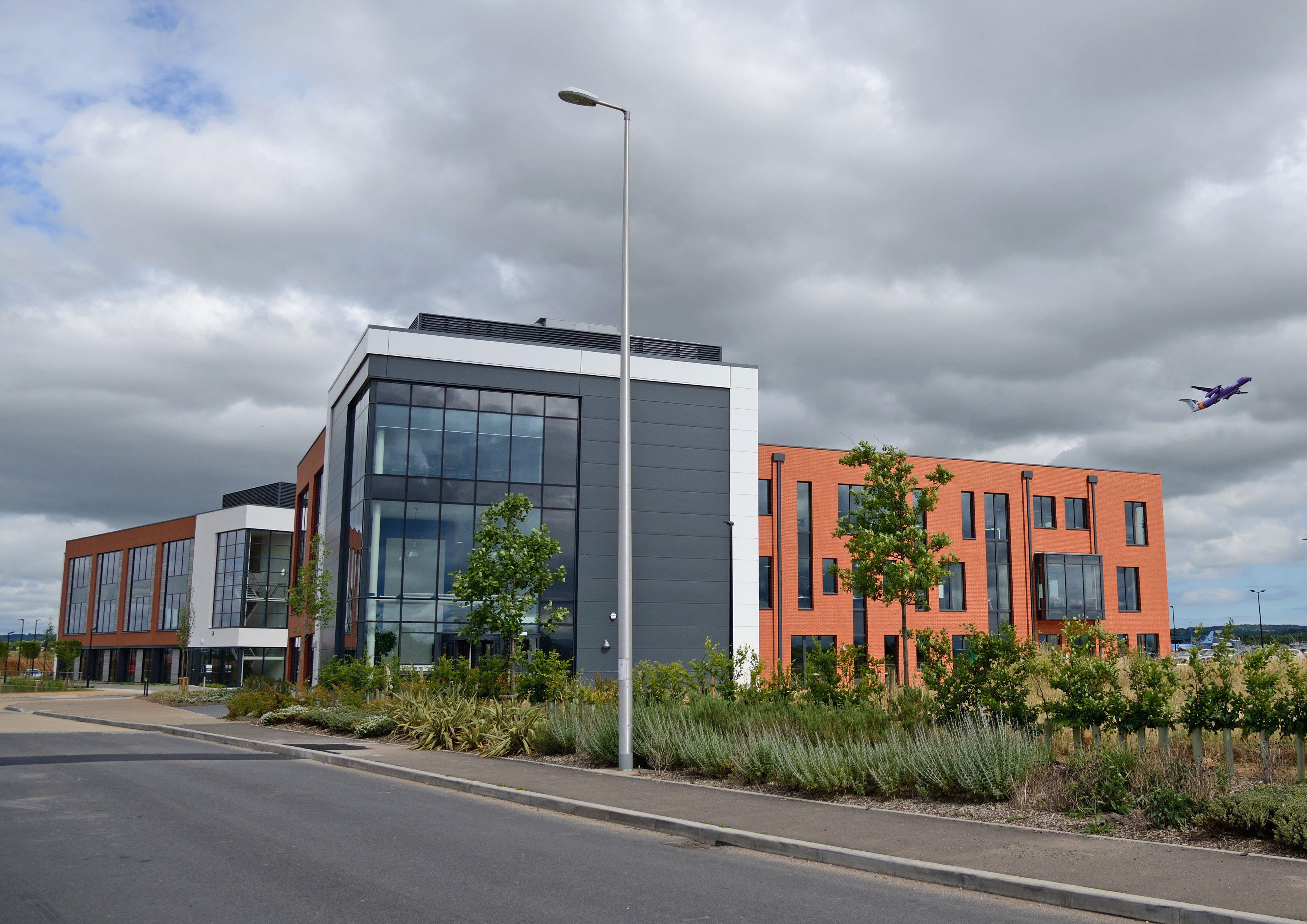
Exeter Skypark
The maps that follow show the areas of land that we think should be designated as new employment sites, in addition to those that we have previously consulted on.
We would welcome your views on whether you think these new sites should be allocated and, if so, whether we have shown appropriate boundaries. If you think that different boundaries would be more appropriate, please tell us where they should go and why. At this stage we are not asking for new sites to be suggested.
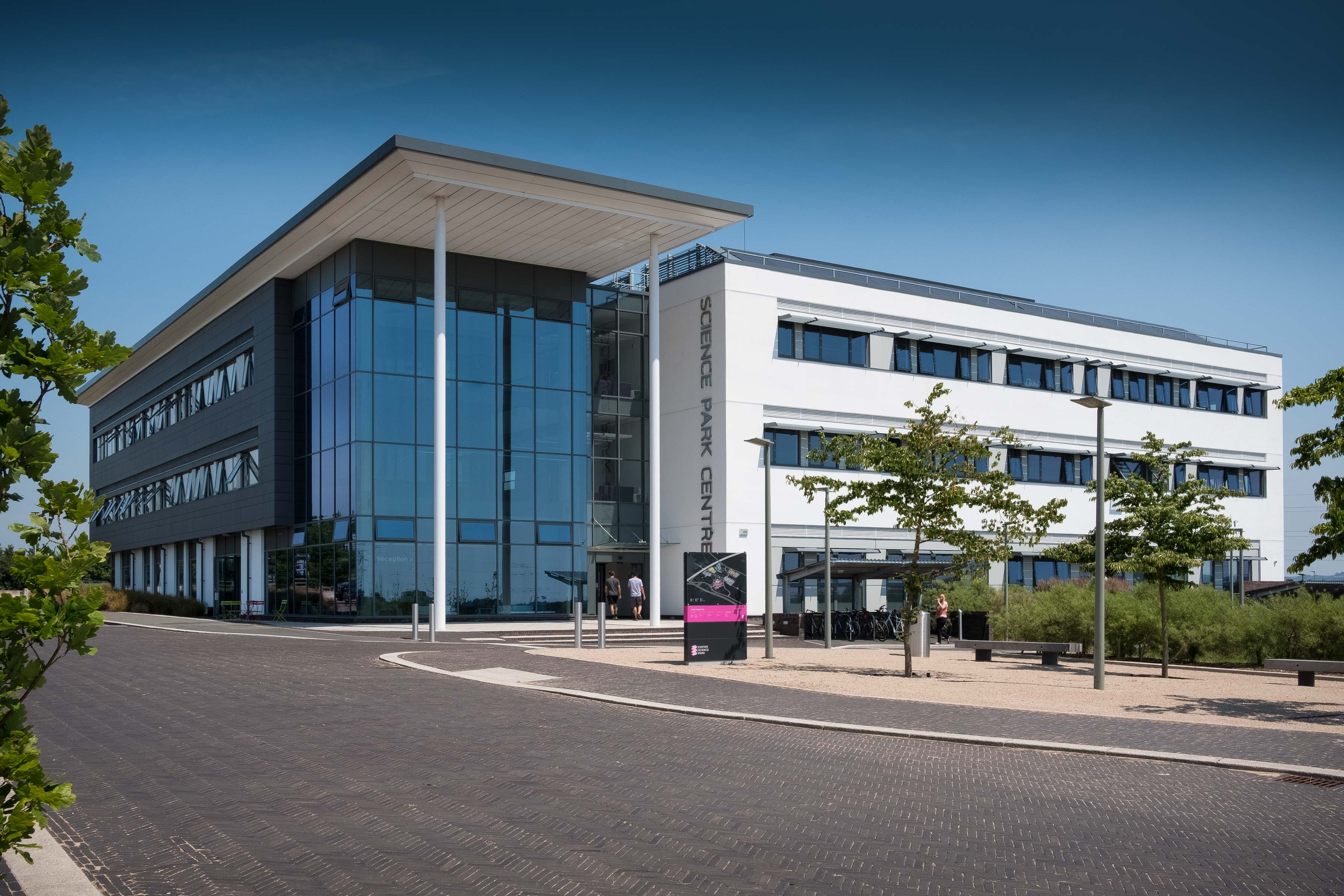
Exeter Science Park Centre
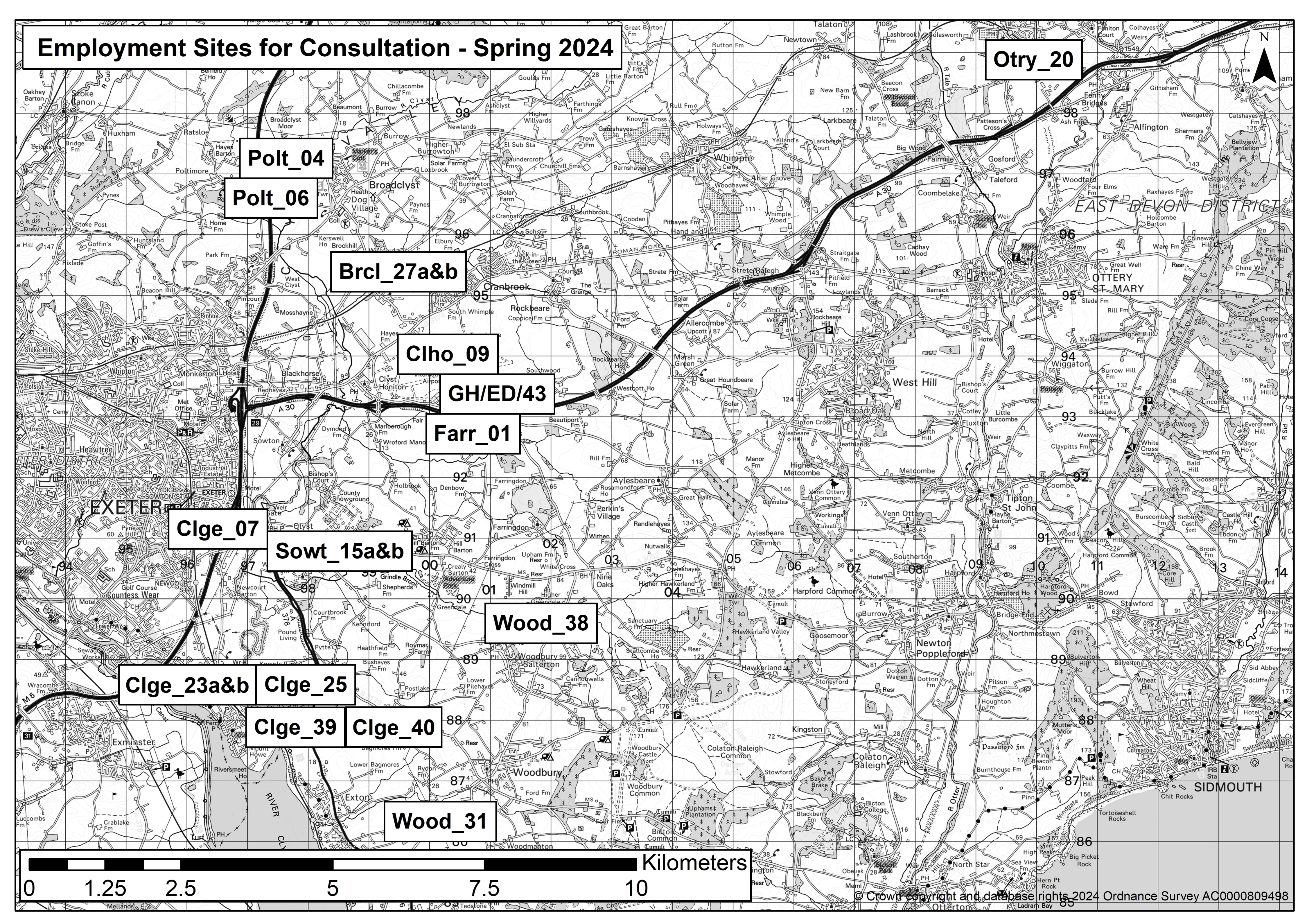
Brcl_27a&b - Lodge Trading Estate, near Broadclyst
Clge_07 - Land south of Sandygate Farm, M5 (Junction 30)
Clge_23a&b - Darts Farm
Clge_25 - Land north-east of Darts Farm
Clge_39 - Land adjacent to Darts Business Park
Clge_40 - Land adjacent to Darts Business Park
Clho_09 - Land to the north of Exeter Airport
Farr_01 - South of Exeter Airport Business Park
GH/ED/43 - Exeter Airport Business Park
Otry_20 - Land lying to the south-east of Bridge Cottages, Feniton
Polt_04 - Land adjacent to the M5, near Poltimore
Polt_06 - Land adjacent to the M5, near Poltimore
Sowt_15a&b - Land adjacent to Oil Mill Lane Industrial Estate
Wood_31 - Land adjoining Woodbury Business Park
Wood_38 - Land adjoining Greendale Business Park
Alternatively, you can view this responsive map
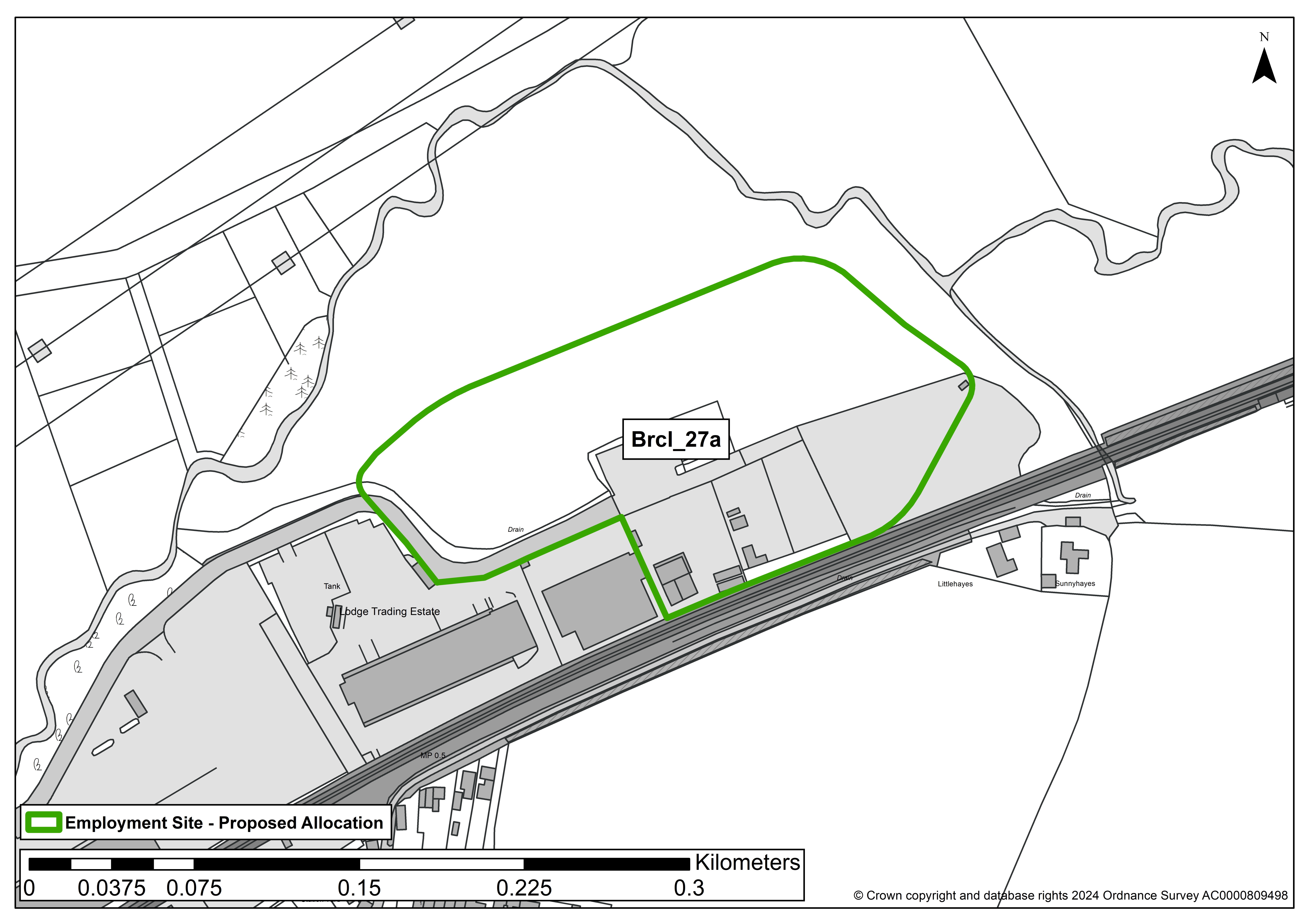
Brcl_27 (n.b. this site has been split into parts a and b)
SITE DETAILS
Location: Lodge Trading Estate, near Broadclyst
Reference number: Brcl_27a
Site area (ha): 1.89
Address: Lodge Trading Estate, Broadclyst Station Road, EX5 3BS
Proposed use: Mixed use/Employment
SITE MAP
SITE ASSESSMENT SUMMARY AND CONCLUSION
Infrastructure
The site contains an existing business park. Devon County Council advise that careful consideration needs to be given to Broadclyst Station, the Western Expansion Area of Cranbrook, and the associated detail in the emerging Cranbrook Plan.
Landscape
Low-medium sensitivity - The site is not in a designated landscape. It does feature in some medium-long range views and is relatively flat and open, but development would be seen in the context of existing development.
Historic environment
Medium sensitivity - There is evidence of prehistoric enclosure and field boundaries. An archaeological survey is needed prior to development and it may be possible to design a layout to incorporate any subterranean remains.
Ecology
Minor adverse harm predicted (not significant). Site lies immediately adjacent to a unconfirmed wildlife site, priority habitat and nature recovery network. Retention of the boundary hedgerow and careful landscaping could minimise any impact on these areas.
Accessibility
Site adjoins the outskirts of Cranbrook and lies approximately halfway between the A30 and Broadclyst in a small hamlet. Accessibility is reasonable and the main road is very well used, albeit prone to flooding and narrow in parts. The site is within 1,600 metres of 4 or more different local facilities and within 1,600 metres of a train station or bus route with an hourly or better service.
Other constraints
Overhead high voltage electricity line with possible easement on a very small part of the northern boundary. No high pressure gas pipeline zones. Site lies adjacent to the Cranny Brook. Approx 4 ha of the total site is in Flood Zone 3. This will impact on the gross development area. An additional 0.9 ha is in Flood Zone 2, Flood zones 2 and 3 are on the northern and eastern boundaries. Area of low risk of surface water flooding in the northern part of the site. Grade 3a and 3b agricultural land.
Within Green Wedge in adopted Local Plan 2013-31 or made Neighbourhood Plan?
No
Opportunities
The site is partly developed, partly overgrown. Opportunity to reuse a brownfield site. Poorly related to Cranbrook despite proximity, due to difficulty with bridging the railway line.
Yield (hectares of employment land)
1.89
Contribution to spatial strategy
Site is located in the countryside but within walking/cycling distance of Cranbrook and a tier 4 settlement. Includes existing business park.
Should the site be allocated?
Yes
Reasons for allocating or not allocating
The site is reasonably well located adjacent to development (and including existing commercial development), close to facilities and public transport. It could function as an expansion to the existing business park. Development could affect subterranean heritage assets. The design would need to protect existing trees and hedgerows and an archaeological assessment would be required.
If whole site is not suitable for allocation, could a smaller part be allocated?
Yes, 1.89 ha is outside the floodplain and not already in an active employment use.
SITE DETAILS
Location: Lodge Trading Estate, near Broadclyst
Reference number: Brcl_27b
Site area (ha): 6.531 (note the site Brcl_27 as originally submitted measured 8.421ha but 1.89ha is proposed as an allocation Brcl_27a)
Address: Lodge Trading Estate, Broadclyst Station Road, EX5 3BS
Proposed use: Mixed use/Employment
SITE MAP
SITE ASSESSMENT SUMMARY AND CONCLUSION
Infrastructure
The site contains an existing business park. Devon County Council advise that careful consideration needs to be given to Broadclyst Station, the Western Expansion Area of Cranbrook, and the associated detail in the emerging Cranbrook Plan.
Landscape
Low-medium sensitivity - The site is not in a designated landscape. It does feature in some medium-long range views and is relatively flat and open, but development would be seen in the context of existing development.
Historic environment
Medium sensitivity - There is evidence of prehistoric enclosure and field boundaries. An archaeological survey is needed prior to development and it may be possible to design a layout to incorporate any subterranean remains.
Ecology
Minor adverse harm predicted (not significant). Site lies immediately adjacent to a unconfirmed wildlife site, priority habitat and nature recovery network. Retention of the boundary hedgerow and careful landscaping could minimise any impact on these areas.
Accessibility
Site adjoins the outskirts of Cranbrook and lies approximately halfway between the A30 and Broadclyst in a small hamlet. Accessibility is reasonable and the main road is very well used, albeit prone to flooding and narrow in parts. The site is within 1,600 metres of 4 or more different local facilities and within 1,600 metres of a train station or bus route with an hourly or better service.
Other constraints
Overhead high voltage electricity line with possible easement on a very small part of the northern boundary. No high pressure gas pipeline zones. Site lies adjacent to the Cranny Brook. Approx 4 ha of the total site is in Flood Zone 3. This will impact on the gross development area. An additional 0.9 ha is in Flood Zone 2, Flood zones 2 and 3 are on the northern and eastern boundaries. Area of low risk of surface water flooding in the northern part of the site. Grade 3a and 3b agricultural land. Part of the site is already developed and the areas in active employment use do not need to be allocated.
Within Green Wedge in adopted Local Plan 2013-31 or made Neighbourhood Plan?
No
Opportunities
The site is partly developed, partly overgrown. Opportunity to reuse a brownfield site. Poorly related to Cranbrook despite proximity, due to difficulty with bridging the railway line.
Yield (hectares of employment land)
6.531ha
Contribution to spatial strategy
Site is located in the countryside but within walking/cycling distance of Cranbrook and a tier 4 settlement. Includes existing business park.
Should the site be allocated?
No
Reasons for allocating or not allocating
The site is reasonably well located adjacent to development (and including existing commercial development), close to facilities and public transport. Part of the site is proposed for allocation. Brcl_27b is not considered suitable for allocation due to the existing active employment uses already in place and the extensive areas that are liable to flooding.
If whole site is not suitable for allocation, could a smaller part be allocated?
Yes, 1.89 ha of the originally submitted Brcl_27 site is proposed for allocation as Brcl_27a. None of this remaining part (Brcl_27b) of the site is considered suitable for allocation.
Clge_07
SITE DETAILS
Location: Land south of Sandygate Farm, M5 J30
Reference number: Clge_07
Site area (ha): 0.72
Address: Land adjacent Martins of Exeter Ltd, Clyst Road, Sandygate, Exeter, EX2 7JL
Proposed use: Employment
SITE MAP
SITE ASSESSMENT SUMMARY AND CONCLUSION
Infrastructure
Devon County Council Highways: Access via Martins only.
Landscape
This site lies to the far west of East Devon, close to the developed extent of Exeter and alongside the busy M5 motorway. It is not within a designated landscape. The site is seen in the context of the adjacent caravan dealerership, M5 and Sandy Park rugby ground, however the views are limited due to the distance and intervening vegetation and hedgerow. Due to these limitations, the overall landscape sensitivity of the site is considered low.
Historic environment
The nearest designated heritage asset is Clyst St Mary bridge, an ancient monument 219m east of site, however there is no intervisibility between the site and the bridge due to the distance and intervening vegetation. The heritage impact is therefore low.
Ecology
The site is covered by unimproved grassland. The site is bounded by hedgerow/vegetation including some mature trees. Clyst Marshes County Wildlife Site lies within 150m and Sowton - Winslade Park Marshes Unconfirmed Wildlife Site lie within 200m however a minor adverse effect predicted (not significant).
Accessibility
The site is within 1,600 metres of four or more different local facilities and within 1,600 metres of a train station or bus route with an hourly or better service.
Other constraints
None identified
Within Green Wedge in adopted Local Plan 2013-31 or made Neighbourhood Plan?
Yes
Opportunities
None identified
Yield (hectares of employment land)
0.72
Contribution to spatial strategy
Located in the Western side of East Devon where the Local Plan focuses new development, including a new town and other major strategic developments close to Exeter.
Should the site be allocated?
Yes
Reasons for allocating or not allocating
The site has good access to existing facilities and employment opportunities. The site has limited impact upon the historic environment, limited impact on the landscape and minor ecological impact.
Direct access from Clyst Road is not currently available but could be provided (with the loss of the existing boundary). Access is currently taken through the adjacent business and, as this is in the same ownership as the site, presumably could be upgraded if necessary.
If whole site is not suitable for allocation, could a smaller part be allocated?
N/A
Clge_23 (n.b. this site has been split into parts a and b)
SITE DETAILS
Location: Darts Farm
Reference number: Clge_23a
Site area (ha): 0.63
Address: Darts Farm, EX3 0QH
Proposed use: Employment
SITE MAP
SITE ASSESSMENT SUMMARY AND CONCLUSION
Infrastructure
Existing developed site. Good road access.
Landscape
Low-medium sensitivity - As a site with existing commercial development on it, in an undesignated landscape, the potential harm is limited.
Historic environment
Low sensitivity - no concerns identified on current evidence, although archaeological mitigation measures may be required. No impact upon an asset is predicted or, if an impact is predicted, the cultural heritage value of the asset(s) would be unaffected.
Ecology
No concerns identified.
Accessibility
The site includes a range of shops and there are community facilities and services within 1600m. There is a frequent bus service. The majority of these facilities are within the village centre although access from the site would be via an unlit main road.
Other constraints
None identified
Within Green Wedge in adopted Local Plan 2013-31 or made Neighbourhood Plan?
Yes
Opportunities
None identified
Yield (hectares of employment land)
0.63ha
Contribution to spatial strategy
The site is not at a tiered settlement but is previously developed and already offers local employment. As such it is suitable for a small amount of additional employment use to meet local needs.
Should the site be allocated?
Yes
Reasons for allocating or not allocating
The sites performs well in all respects. As it is largely developed already, there is limited space for further development. It is recommended that an area 0.63ha to the north east of the site be allocated for employment
If whole site is not suitable for allocation, could a smaller part be allocated?
Yes - 0.63ha to the north east could be allocated for employment
SITE DETAILS
Location: Darts Farm
Reference number: Clge_23b
Site area (ha): 2.7ha (note the site Clge_23 as originally submitted measured 3.3ha but 0.63ha is proposed as an allocation Clge_23a)
Address: Darts Farm, EX3 0QH
Proposed use: Employment
SITE MAP 
SITE ASSESSMENT SUMMARY AND CONCLUSION
Infrastructure
Existing developed site. Good road access.
Landscape
Low-medium sensitivity - As a site with existing commercial development on it, in an undesignated landscape, the potential harm is limited.
Historic environment
Low sensitivity - no concerns identified on current evidence, although archaeological mitigation measures may be required. No impact upon an asset is predicted or, if an impact is predicted, the cultural heritage value of the asset(s) would be unaffected.
Ecology
No concerns identified.
Accessibility
The site includes a range of shops and there are community facilities and services within 1600m. There is a frequent bus service. The majority of these facilities are within the village centre although access from the site would be via an unlit main road.
Other constraints
None identified
Within Green Wedge in adopted Local Plan 2013-31 or made Neighbourhood Plan?
Yes
Opportunities
None identified
Yield (hectares of employment land)
2.7ha
Contribution to spatial strategy
The site is not at a tiered settlement but is previously developed and already offers local employment. As such it is suitable for a small amount of additional employment use to meet local needs.
Should the site be allocated?
No
Reasons for allocating or not allocating
The sites performs well in all respects. As it is largely developed already, there is limited space for further development. Part of the site is proposed for allocation. Clge_23b is not considered suitable for allocation due to the existing active employment/retail and associated uses already in place.
If whole site is not suitable for allocation, could a smaller part be allocated?
Yes - 0.63ha of the originally submitted Clge_23 site is proposed for allocation as Clge_23a. None of this remaining part (Clge_23b) of the site is considered suitable for allocation.
Clge_25
SITE DETAILS
Location: Land NE of Darts Farm
Reference number: Clge_25
Site area (ha): 4.51
Address: Land adjoining Darts Farm, EX3 0QH
Proposed use: Mixed Use
SITE MAP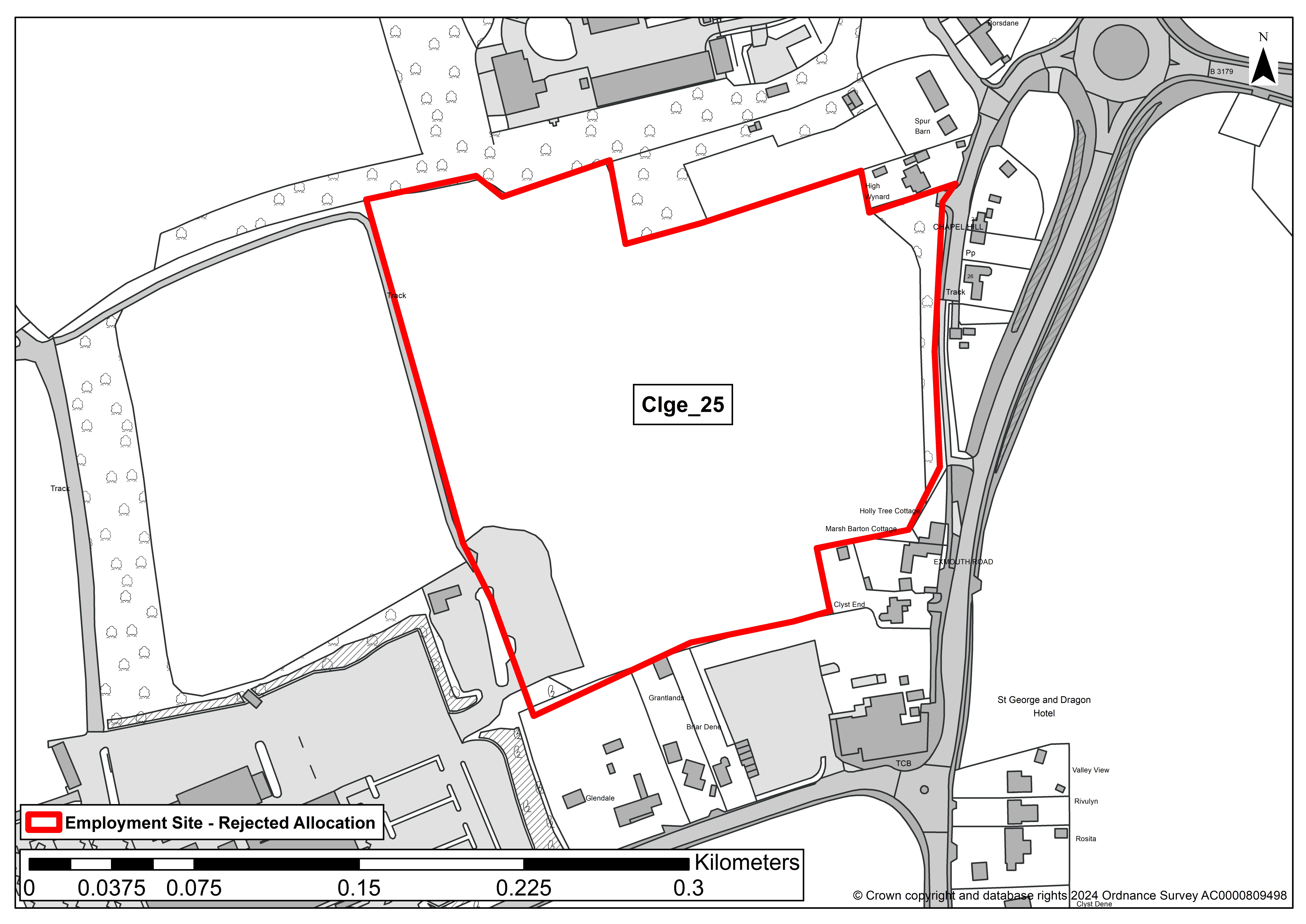
SITE ASSESSMENT SUMMARY AND CONCLUSION
Infrastructure
Would need a new access or potentially could share Dart's Farm access. Close to facilities and bus route.
Landscape
Medium sensitivity - The site is an undeveloped, open field with some existing development around it.
Historic environment
Low sensitivity - No concerns identified on current evidence, although archaeological mitigation measures may be required. No impact upon an asset is predicted or, if an impact is predicted, the cultural heritage value of the asset(s) would be unaffected.
Ecology
Minor adverse effect, although a hedgerow may need to be removed to facilitate access.
Accessibility
The site lies adjacent to a small range of shops and there are community facilities and services within 1600m. There is a frequent bus service. The majority of these facilities are within the village centre although access from the site would be via an unlit main road.
Other constraints
None identified
Within Green Wedge in adopted Local Plan 2013-31 or made Neighbourhood Plan?
Yes
Opportunities
None identified
Yield (hectares of employment land)
4.51
Contribution to spatial strategy
The site is not at a tiered settlement and is an undeveloped field in open countryside. Although it lies adjacent to a site which offers local employment (hence it progressing to stage 3 assessment), that site can accommodate the additional employment required to meet local needs.
Should the site be allocated?
No
Reasons for allocating or not allocating
This site performs reasonably well but it is not required as sufficient employment land to serve local needs can already be accommodated on the adjoining site.
If whole site is not suitable for allocation, could a smaller part be allocated?
No
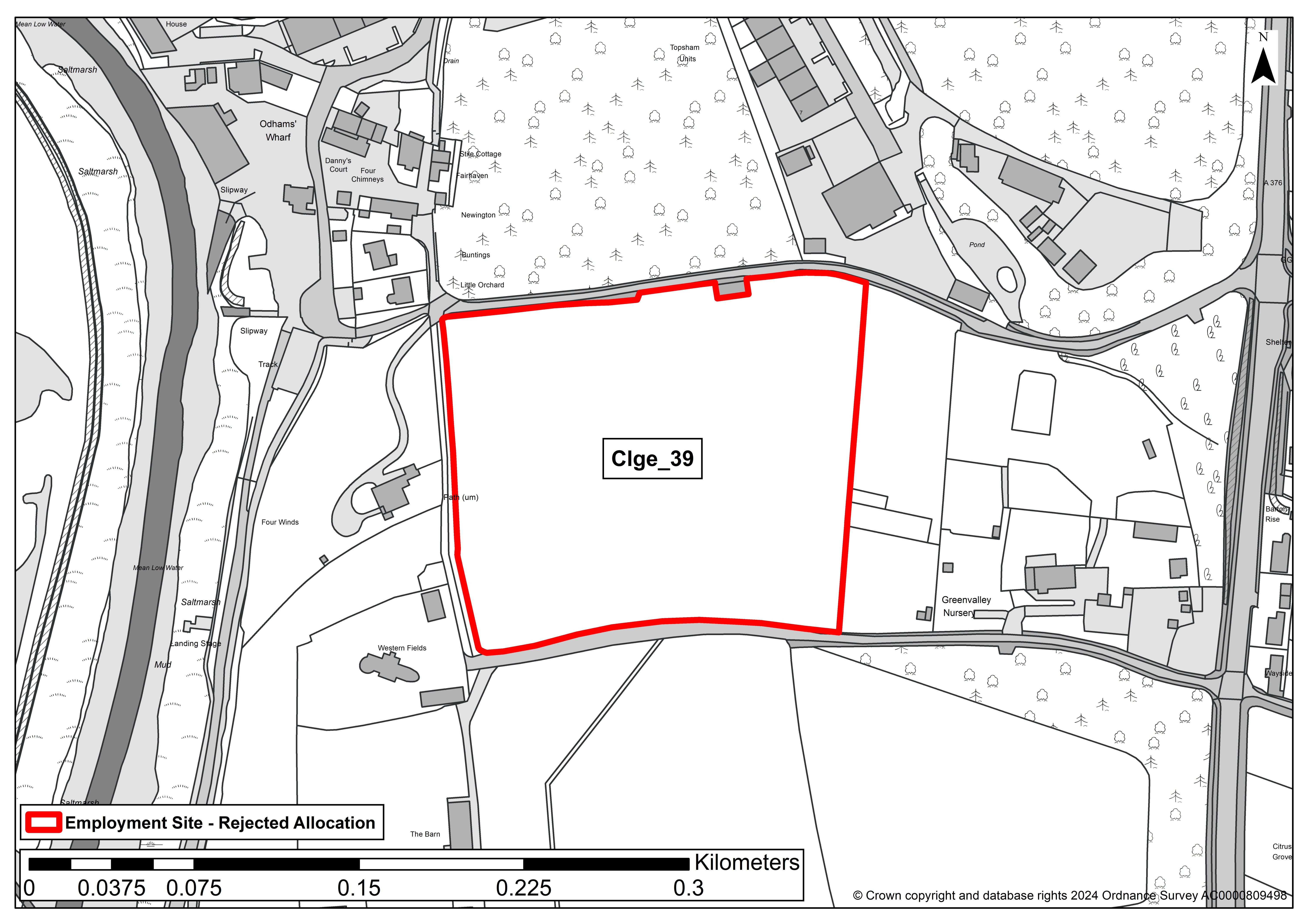
Clge_39
SITE DETAILS
Location: Adj. Darts Business Pk
Reference number: Clge_39
Site area (ha): 2.77
Address: Land south of Old Ebford Lane, Ebford, EX3 0GA
Proposed use: Employment
SITE MAP
SITE ASSESSMENT SUMMARY AND CONCLUSION
Infrastructure
Nearby highway network already has capacity issues
Landscape
Development of any part of the site will urbanise a currently rural area. Visual impact will be significantly increased if a major access is required. Sensitivity is increased because the site is bounded by footpaths/cycleways which access the wider footpath/cycle network along the Exe Estuary approx 100m away.
Historic environment
Medium sensitivity - There is evidence of medieval earthworks and field remnants. An archaeological survey is needed prior to development and it may be possible to design a layout to incorporate any subterranean remains.
Ecology
Minor adverse harm predicted (not significant). Despite proximity to the nationally important River Exe and estuary development is unlikely to have a significant impact due to intervening land uses.
Accessibility
Site lies between Ebford and Clyst St George (Approx 400m and 800m respectively). There is a nearby bus service on the main road. The site is bounded by public footpaths on three sides. Access roads to the north and south are very narrow country lanes.
Other constraints
Grade 1 agricultural land (a very small area to the north west corner is Grade 2).
Within Green Wedge in adopted Local Plan 2013-31 or made Neighbourhood Plan?
Yes
Opportunities
None identified
Yield (hectares of employment land)
2.77
Contribution to spatial strategy
Site is located in the countryside but within walking/cycling distance of two tier 4 settlements. Close to existing business park.
Should the site be allocated?
No
Reasons for allocating or not allocating
Site is located in a rural position accessed along single track roads. Development, along with additional commercial traffic, would change the character to an unacceptable degree. Grade 1 agricultural land.
If whole site is not suitable for allocation, could a smaller part be allocated?
No
Clge_40
SITE DETAILS
Location: Adj. Darts Business Pk
Reference number: Clge_40
Site area (ha): 3.34
Address: Land south of Topsham Road, Clyst St George, EX3 0QH
Proposed use: Employment
SITE MAP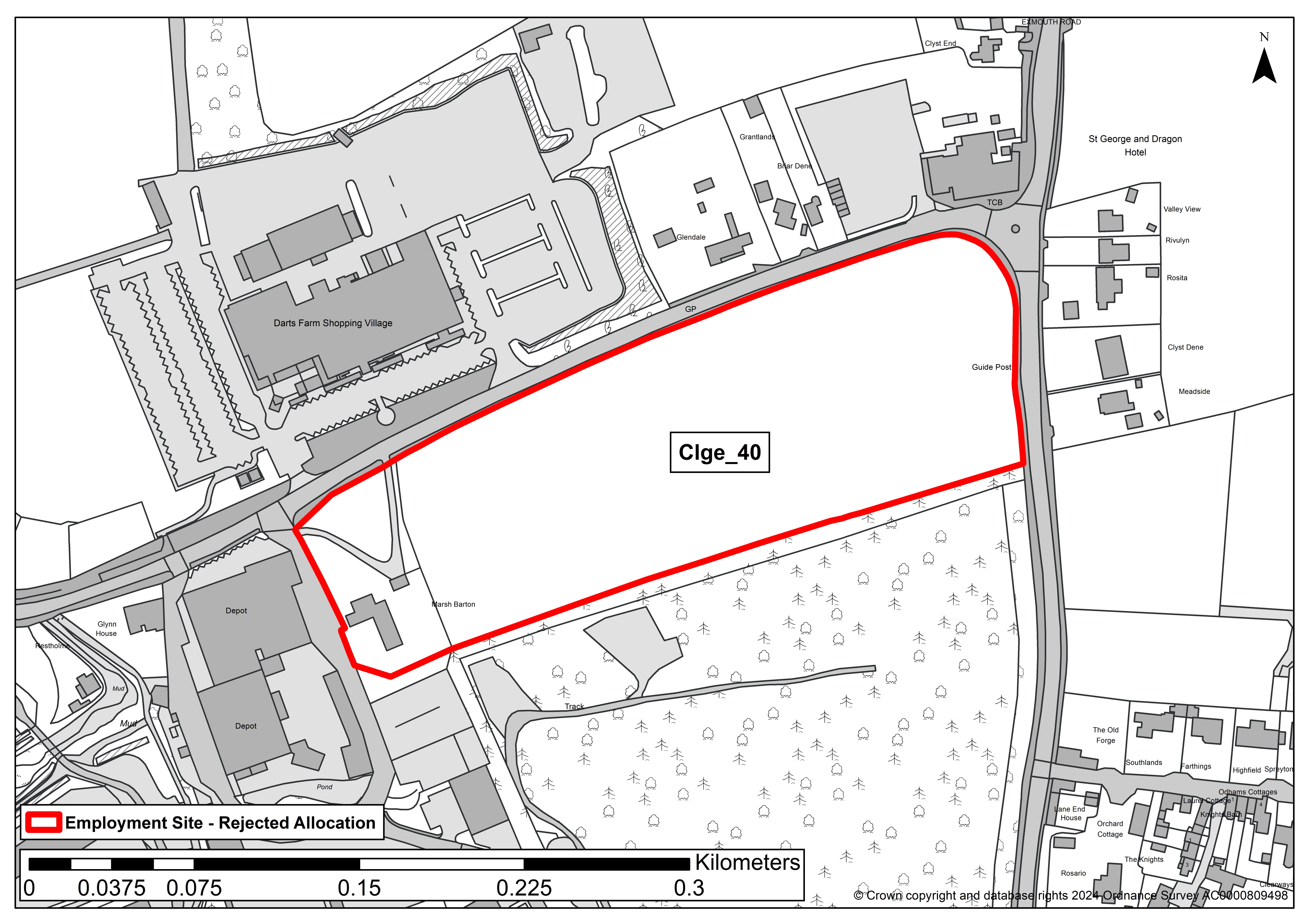
SITE ASSESSMENT SUMMARY AND CONCLUSION
Infrastructure
Nearby highway network already has capacity issues.
Landscape
Low-medium sensitivity - The site is not in a designated landscape. It does feature in some medium-long range views and is relatively flat and open, but development of the western end would be seen in the context of existing development.
Historic environment
Moderate sensitivity - A Grade 2 listed farmhouse and it's garden lie within the western section of the site and there is potential for harm. It is recommended that any development be restricted to the eastern field and not encroach onto the farmhouse garden in any way. Harm could be reduced through landscaping, design, reducing density and height, and reflecting the agricultural character of the area.
Ecology
Minor adverse harm predicted (not significant). Despite proximity to the nationally important River Exe and estuary development is unlikely to have a significant impact due to intervening land uses.
Accessibility
Site lies between Ebford and Clyst St George (approx 400m from each). There is a nearby bus service. The site is opposite an existing shopping/retail park and there are several other businesses nearby.
Other constraints
Grade 1 agricultural land.
Within Green Wedge in adopted Local Plan 2013-31 or made Neighbourhood Plan?
Yes
Opportunities
Yield (hectares of employment land)
2.9
Contribution to spatial strategy
Site is located in open countryside, albeit close to a tiered settlement, adjacent to a small business park and opposite a retail park.
Should the site be allocated?
No
Reasons for allocating or not allocating
The site is reasonably well located but it forms the pastoral setting to the Grade 2 listed farmhouse to the west. The site is quite exposed, so development will be highly visible, and the land is Grade 1.
If whole site is not suitable for allocation, could a smaller part be allocated?
No
Clho_09
SITE DETAILS
Location: Land to north of Exeter Airport
Reference number: Clho_09
Site area (ha): 15.3
Address: Land to north (Phase 1) of Exeter International Airport, Exeter, Devon (37.51 acres), EX5 2BD
Proposed use: Employment
SITE MAP
SITE ASSESSMENT AND SUMMARY
Infrastructure
Poor access, very close to airport.
Landscape
Low sensitivity - the landscape is previously developed/degraded.
Historic environment
Moderate sensitivity - Change affecting the special character of assets, where elements which contribute to their significance and their setting are harmed. The site was formerly farmland but was built as an RAF airfield in the 1940's. The site contains infrastructure on the HER associated with the airfield use.
Ecology
No concerns identified.
Accessibility
The site lies close to Cranbrook and employment uses, within the airfield, although these are not easily accessible. It will adjoin the Treasbeare expansion area but that is not yet developed.
Other constraints
Within the airport safeguarding and noise zones.
Within Green Wedge in adopted Local Plan 2013-31 or made Neighbourhood Plan?
No
Opportunities
None identified
Yield (hectares of employment land)
15.3
Contribution to spatial strategy
The site is not at a tiered settlement, although it will be in future.
Should the site be allocated?
No
Reasons for allocating or not allocating
This site performs reasonably well but it is not required as sufficient employment land can already be accommodated on more accessible and better related sites.
If whole site is not suitable for allocation, could a smaller part be allocated?
No
Farr_01
SITE DETAILS
Location: South of Exeter Airport Business Park
Reference number: Farr_01
Site area (ha): 1
Address: Wares Farm, Clyst Honiton Exeter, EX5 2BL
Proposed use: Employment
SITE MAP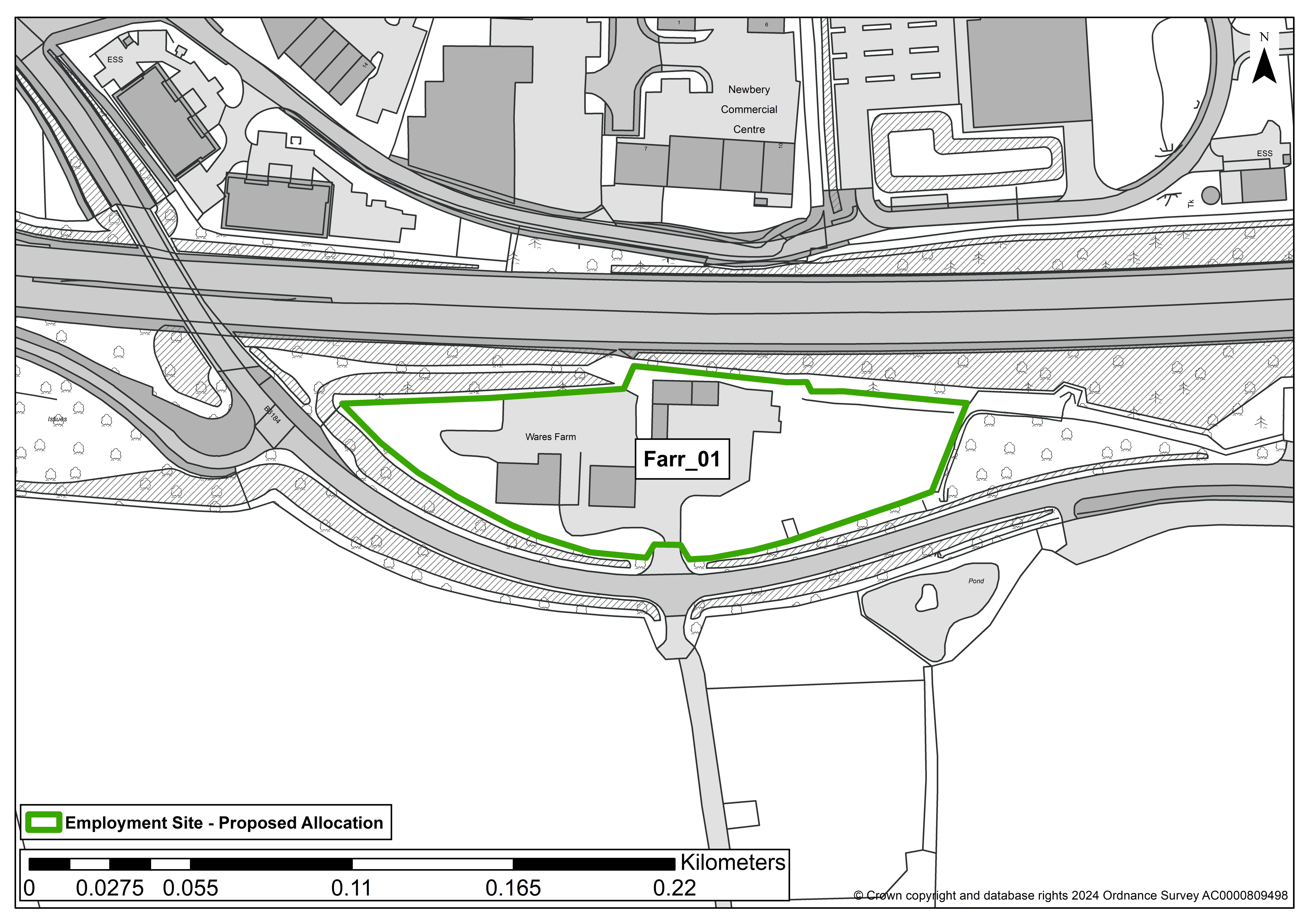
SITE ASSESSMENT SUMMARY AND CONCLUSION
Infrastructure
Close to existing employment site, albeit on opposite sides of the A30. Access may need to be upgraded.
Landscape
Medium sensitivity - Non-designated rural landscape dominated by trunk road.
Historic environment
High-Medium sensitivity - Further assessment is needed to confirm significance as little remains but the site was formerly a farmyard serving surrounding fields and potentially dating from 1452, however the A30 adjoins the site and has totally severed it from the surroundings.
Ecology
Minor adverse effect predicted (not significant).
Accessibility
Close to existing employment site and bus stop.
Other constraints
Grade 2 Agricultural land.
Within Green Wedge in adopted Local Plan 2013-31 or made Neighbourhood Plan?
No
Opportunities
There are no specific identified opportunities that site development might help deliver.
Yield (hectares of employment land)
1
Contribution to spatial strategy
The site is not at a tiered settlement, it is in open countryside, albeit very closely related to an existing employment site.
Should the site be allocated?
Yes
Reasons for allocating or not allocating
The site performs well and could provide an alternative to the very high quality employment sites at the Airport.
If whole site is not suitable for allocation, could a smaller part be allocated?
N/A
GH/ED/43
SITE DETAILS
Location: Exeter Airport Business Park
Reference number: GH/ED/43
Site area (ha): 11.8
Address: Land north of Long Lane, adjacent Exeter International Airport
Proposed use: Employment
SITE MAP
SITE ASSESSMENT SUMMARY AND CONCLUSION
Infrastructure
The site adjoins an existing business park. There may be access constraints but Long Lane is undergoing/has undergone improvements. Wider junction capacity constraints
Landscape
Low sensitivity
Historic environment
Moderate sensitivity - Change affecting the special character of assets, where elements which contribute to their significance and their setting are harmed. The site is within the RAF airfield, a non-designated heritage asset
Ecology
Minor adverse effect predicted (not significant)
Accessibility
Site lies within the West End, in close proximity to employment development.
Other constraints
Access can be achieved through existing field gate off Long Lane and then past the airport main entrance.
Alternative access could potentially be achieved through provision of a new junction on the A30, to serve this allocation and surrounding sites. Development has potential to impact on Junction 29 of the M5, which suffers congestion at peak periods.
The centre of the site is approx 2.3km from Cranbrook train station, although the airport’s location means that the route is actually far longer.
The Exmouth-Woodbury-Airport-Exeter bus serves the airport terminal and the site is a short walk from here. Pedestrian/cycle access to the airport terminal and other West End sites would need to be greatly improved.
Within Green Wedge in adopted Local Plan 2013-31 or made Neighbourhood Plan?
No
Opportunities
None identified
Yield (hectares of employment land)
11.8
Contribution to spatial strategy
The site is not at a tiered settlement, it is in open countryside, albeit very closely related to an existing employment site
Should the site be allocated?
Yes
Reasons for allocating or not allocating
The site is well located in the West End adjacent to an existing employment area (and forming an extension to it). Road improvements are required but these are planned for.
If whole site is not suitable for allocation, could a smaller part be allocated?
Not applicable
Otry_20
SITE DETAILS
Location: Feniton
Reference number: Otry_20
Site area (ha): 4.64
Address: Land Lying To The South-East Of Bridge Cottages, Feniton, EX14 3BR
Proposed use: Employment
SITE MAP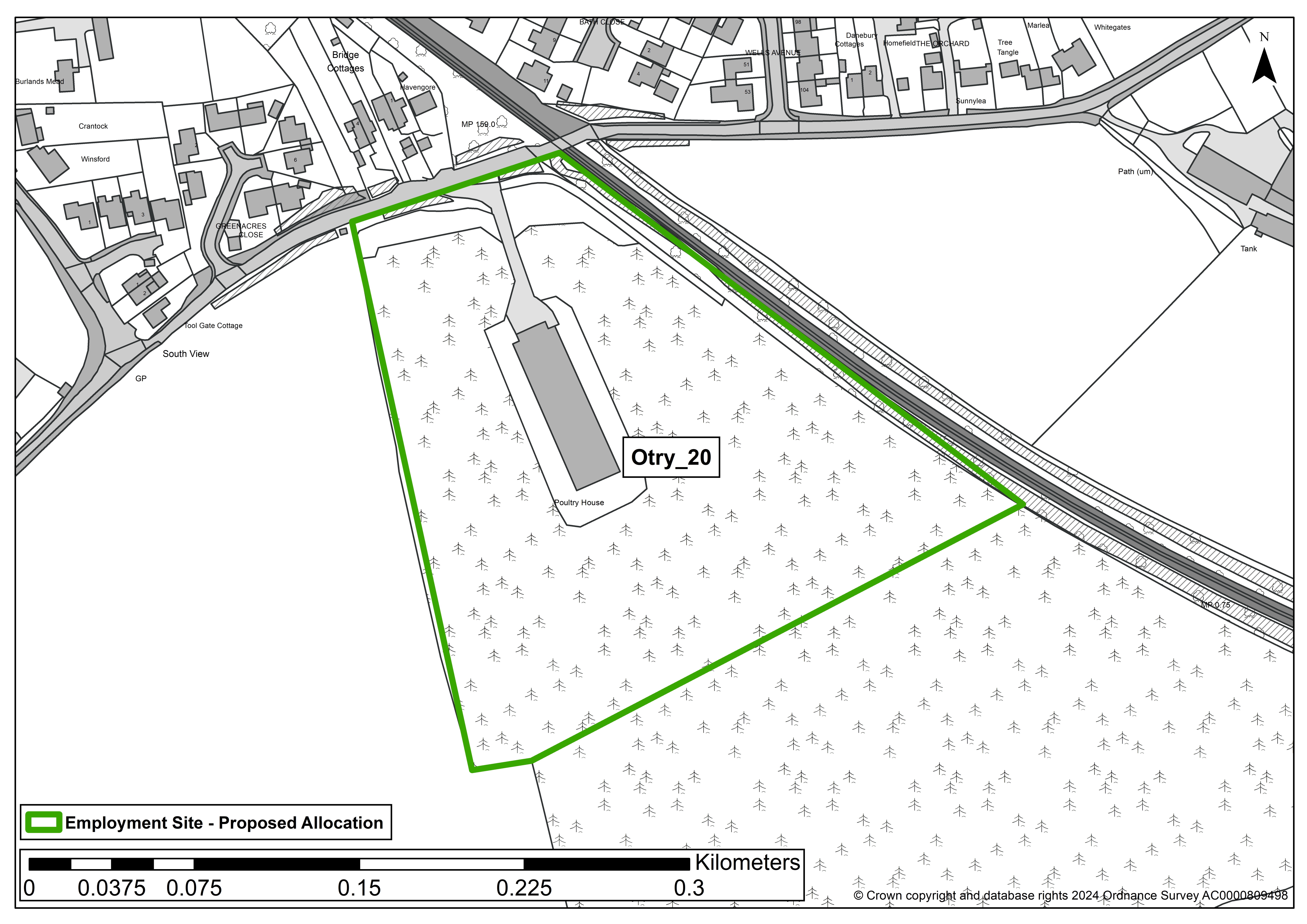
SITE ASSESSMENT SUMMARY AND CONCLUSION
Infrastructure
There are no infrastructure matters identified.
Landscape
The site juts out in a south easterly direction from the existing built form of Feniton and would constitute new development south of Green Lane that for the most part forms the southerly boundary of built development in/at the village. The site is, however, flat and quite low lying and with some mature planting to parts of site boundaries. The site is currently predominantly used as an orchard, though with a poultry house within. The north-easterly boundary of the site is bounded by the railway and this limits views in, however a public footpath runs along the westerly boundary and this has a more visually open aspect to the site.
Historic environment
The nearest Listed building to the site is the Grade II Metcombe Cottage which is around 200 metres to the west and at this distance, and noting existing mature vegetation, there is limited visual connectivity between the site and this property. Whilst a large scale, high, development may have some degree of adverse impact this is likely to be limited and mitigation, or more simply low level development, should address concerns.
Ecology
There are no designated wildlife sites in close proximity of the site nor other nearby features or areas of wildlife importance that development could be expected to adversely impact on. Being a site that is intensively managed for fruit production it is liable to have limited on site wildlife value. However tree coverage, with some mature trees, to boundaries are likely to be of some value.
Accessibility
The site falls within 1,600 metres of the modest range of services and facilities that are available in Feniton.
Other constraints
No identified constraints to development are noted.
Within Green Wedge in adopted Local Plan 2013-31 or made Neighbourhood Plan?
No
Opportunities
No specific opportunities are identified.
Yield (hectares of employment land)
4.64
Contribution to spatial strategy
Feniton is a Service Village where there should be limited development to meet local needs.
Should the site be allocated?
Yes
Reasons for allocating or not allocating
Yes - but depending on quantified needs assessment work. It is concluded that, for employment uses only, the site would be a credible option for allocation. However, this maybe applicable to part of the site only.
If whole site is not suitable for allocation, could a smaller part be allocated?
Not applicable.
Polt_04
SITE DETAILS
Location: Adj. M5 near Poltimore
Reference number: Polt_04
Site area (ha): 34.2
Address: Land at Poltimore Barton, Poltimore, EX4 0BQ
Proposed use: Employment/Service Station
SITE MAP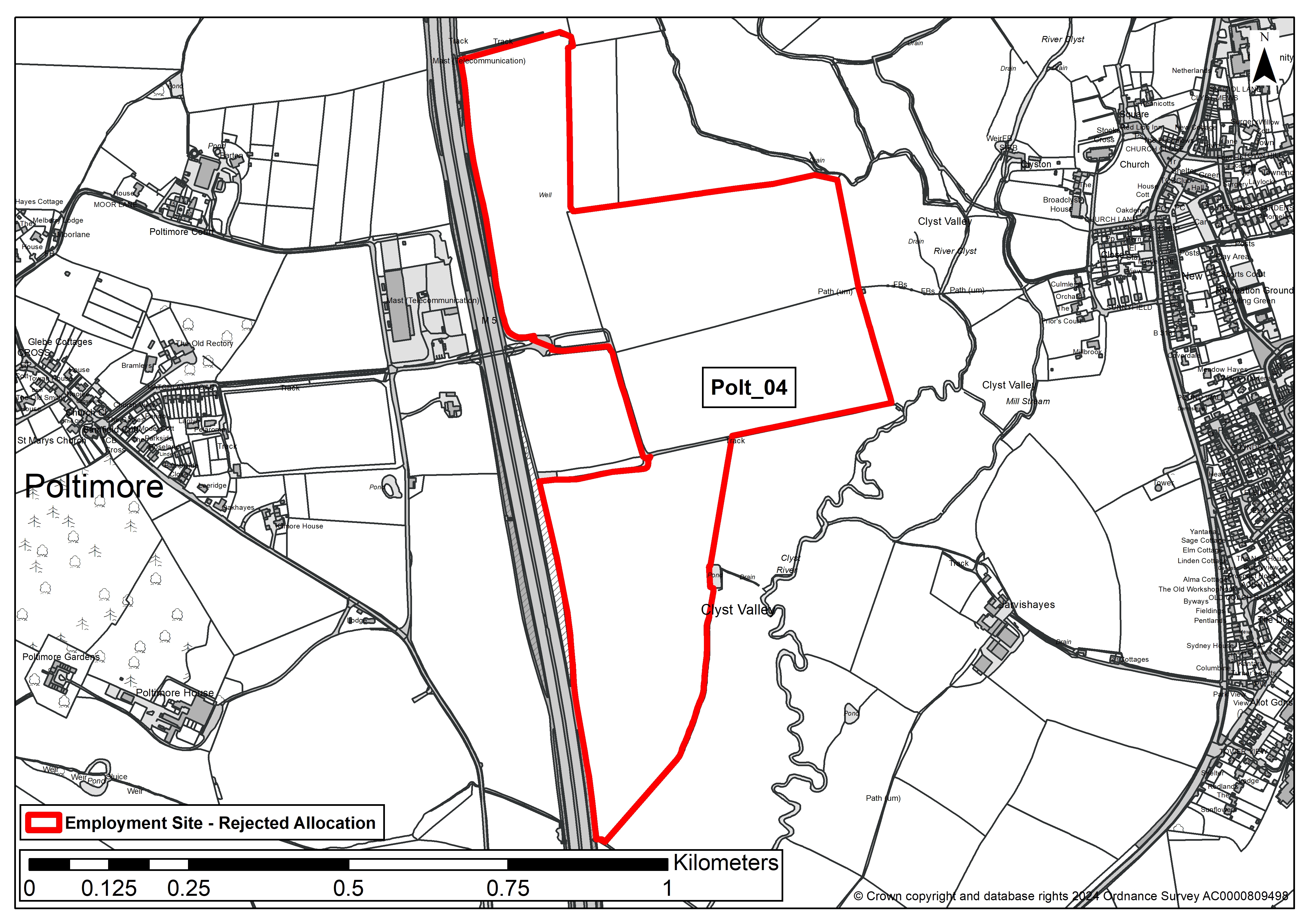
SITE ASSESSMENT SUMMARY AND CONCLUSION
Infrastructure
Devon County Council Comments: Large combination of sites. Distant from Stoke Canon Primary which has some capacity to support development - consider in relation to Pinhoe. New primary and secondary capacity required, and depending on provision, transport costs would apply for primary and secondary. Need to be considered alongside west end development and Exeter development plans. We would have no problem with self-contained services for the M5 in this location being in the next local plan as long as there is no through route to the local highway network.
Landscape
Medium sensitivity - the topography is such that the development would be visible in long range views.
Historic environment
High sensitivity - contains several Historic Environment Record's but also impacts on the Deer Park setting of nearby Grade 2* listed Poltimore House.
Ecology
Minor adverse effect predicted (not significant).
Accessibility
The site is within 1,600 metres of four or more different local facilities and within 1,600 metres of a train station or bus route with an hourly or better service.
Other constraints
Approx. 1.1 ha of the site is in Flood Zone 3. It may contain some Grade 1. agricultural land.
Within Green Wedge in adopted Local Plan 2013-31 or made Neighbourhood Plan?
No
Opportunities
None identified
Yield (hectares of employment land)
34.2
Contribution to spatial strategy
The site is in open countryside, however it adjoins the motorway and (if the emerging spatial strategy requires a services) this is one of a very limited locations where the development could be located.
Should the site be allocated?
No
Reasons for allocating or not allocating
Probably unachievable for all employment uses, except possibly for motorway services, if there is evidence of need for these services; and subject to not linking on to the local highway network. No confirmation that a services is required. Moderate impact on the agricultural setting of Grade 2* Poltimore House, parkland and associated Grade 2 listed buildings.
If whole site is not suitable for allocation, could a smaller part be allocated?
No
Polt_06
SITE DETAILS
Location: Adj. M5 near Poltimore
Reference number: Polt_06
Site area (ha): 45.2
Address: Land at Poltimore/Broadclyst, EX4 0BQ
Proposed use: Employment/Service Station
SITE MAP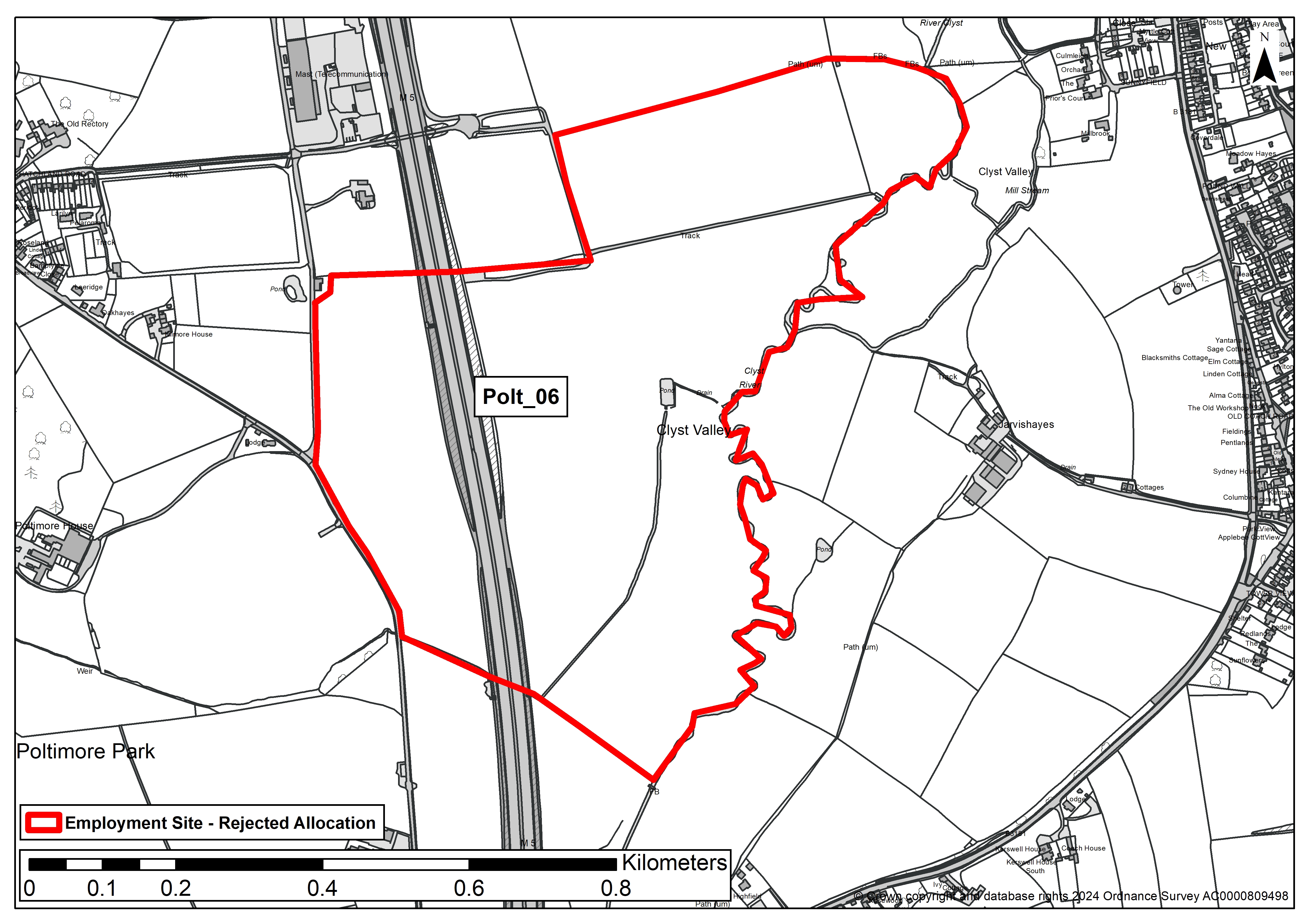
SITE ASSESSMENT SUMMARY AND CONCLUSION
Infrastructure
Devon County Council Comments: Large combination of sites. Distant from Stoke Canon Primary which has some capacity to support development - consider in relation to Pinhoe. New primary and secondary capacity required, and depending on provision, transport costs would apply for primary and secondary. Need to be considered alongside west end development and Exeter development plans. We would have no problem with self-contained services for the M5 in this location being in the next local plan as long as there is no through route to the local highway network.
Landscape
Medium sensitivity - The topography is such that the development would be visible in long range views.
Historic environment
High sensitivity - Contains several Historic Environment Record's but also impacts on the Deer Park setting of nearby Grade 2* listed Poltimore House.
Ecology
Minor adverse effect predicted (not significant).
Accessibility
The site is within 1,600 metres of 4 or more different local facilities and within 1,600 metres of a train station or bus route with an hourly or better service.
Other constraints
Approx. 16 ha of the site is in Flood Zone 3.
Within Green Wedge in adopted Local Plan 2013-31 or made Neighbourhood Plan?
No
Opportunities
None identified
Yield (hectares of employment land)
45.2
Contribution to spatial strategy
The site is in open countryside, however it adjoins the motorway and (if the emerging spatial strategy requires a services) this is one of a very limited locations where the development could be located
Should the site be allocated?
No
Reasons for allocating or not allocating
Probably unachievable for all employment uses, except possibly for motorway services, if there is evidence of need for these services; and subject to not linking on to the local highway network. No confirmation that a services is required. Moderate impact on the agricultural setting of Grade 2* Poltimore House, parkland and associated Grade 2 listed buildings.
If whole site is not suitable for allocation, could a smaller part be allocated?
No
Sowt_15 (n.b. this site has been split into parts a and b)
SITE DETAILS
Location: Adj. Oil Mill Ln Ind Est
Reference number: Sowt_15a
Site area (ha): 1
Address: Langdon Business Park Sidmouth Road, Clyst St Mary, EX5 1AF
Proposed use: Employment
SITE MAP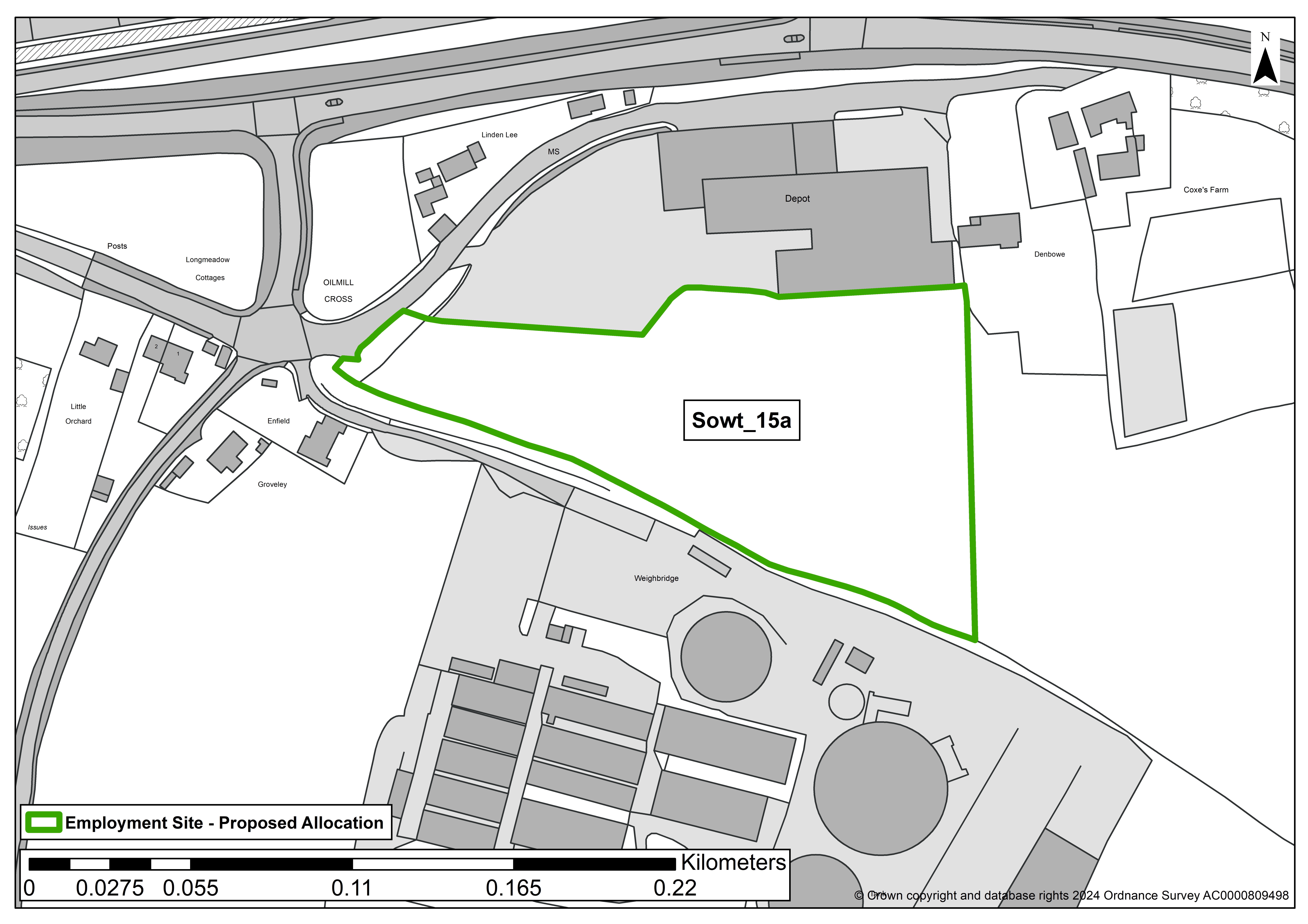
SITE ASSESSMENT SUMMARY AND CONCLUSION
Infrastructure
Existing business park with established access, limited in size, reasonable road collision record within vicinity.
Landscape
The sensitivity varies across the site and increases to the east. Any development should be restricted to the west of the site, between Langdon's Business Park and the commercial buildings to the south. Visual impact will be significantly increased if a new access onto A3052 is required. The development boundaries should be landscaped with a hedge of native species and a strip of woodland to soften the transition between the remaining field and new development.
Historic environment
Medium sensitivity - No significant effects which cannot be mitigated. An impact is predicted, but would not compromise the asset(s) cultural heritage value to the extent that the attributes that led to its designation, or ability to understand or appreciate its value, are diminished or compromised. Mitigation may make the impact acceptable, this is likely to be in the form. The overall significance of the asset would not therefore be materially changed.
Ecology
Minor adverse effect predicted (not significant)
Accessibility
The site lies around 400m from Clyst St Mary, adjacent to an existing business park with established access and close to a pub, an exhibition centre and a residential caravan park. Bus stop within easy walking distance (although there is limited pavement).
Other constraints
Protected trees lie within and in the boundary of the site. These would require protection.
Within Green Wedge in adopted Local Plan 2013-31 or made Neighbourhood Plan?
No
Opportunities
The existing business park could be extended, providing an opportunity for existing businesses to expand.
Yield (hectares of employment land)
1
Contribution to spatial strategy
Site is located in the countryside but within walking/cycling distance of a tier 4 settlement. Adjoins existing business park.
Should the site be allocated?
Yes
Reasons for allocating or not allocating
The site is reasonably well located adjacent and opposite development, close to facilities and public transport. It could function as an expansion to the existing business park. Development of the whole site would be excessive and inappropriate visually, it could also affect heritage assets. Restricting development to the western part of the site would be more appropriate, although the design would need to protect existing trees and an archaeological assessment would be required.
If whole site is not suitable for allocation, could a smaller part be allocated?
Yes, approximately 1ha to the west of the site could be allocated provided existing trees are protected and an archaeological assessment is undertaken. Landscaping should also be undertaken along the new eastern field boundary of the allocation.
SITE DETAILS
Location: Adj. Oil Mill Lane Industrial Estate
Address: Darts Farm, EX3 0QH
Proposed use: Employment
Reference number: Sowt_15b
Site area (ha): 8.55 (note the site Sowt_15 as originally submitted measured 9.55ha but 1ha is proposed as an allocation Sowt_15a)
Address: Langdon Business Park Sidmouth Road, Clyst St Mary, EX5 1AF
Proposed use: Employment
SITE MAP
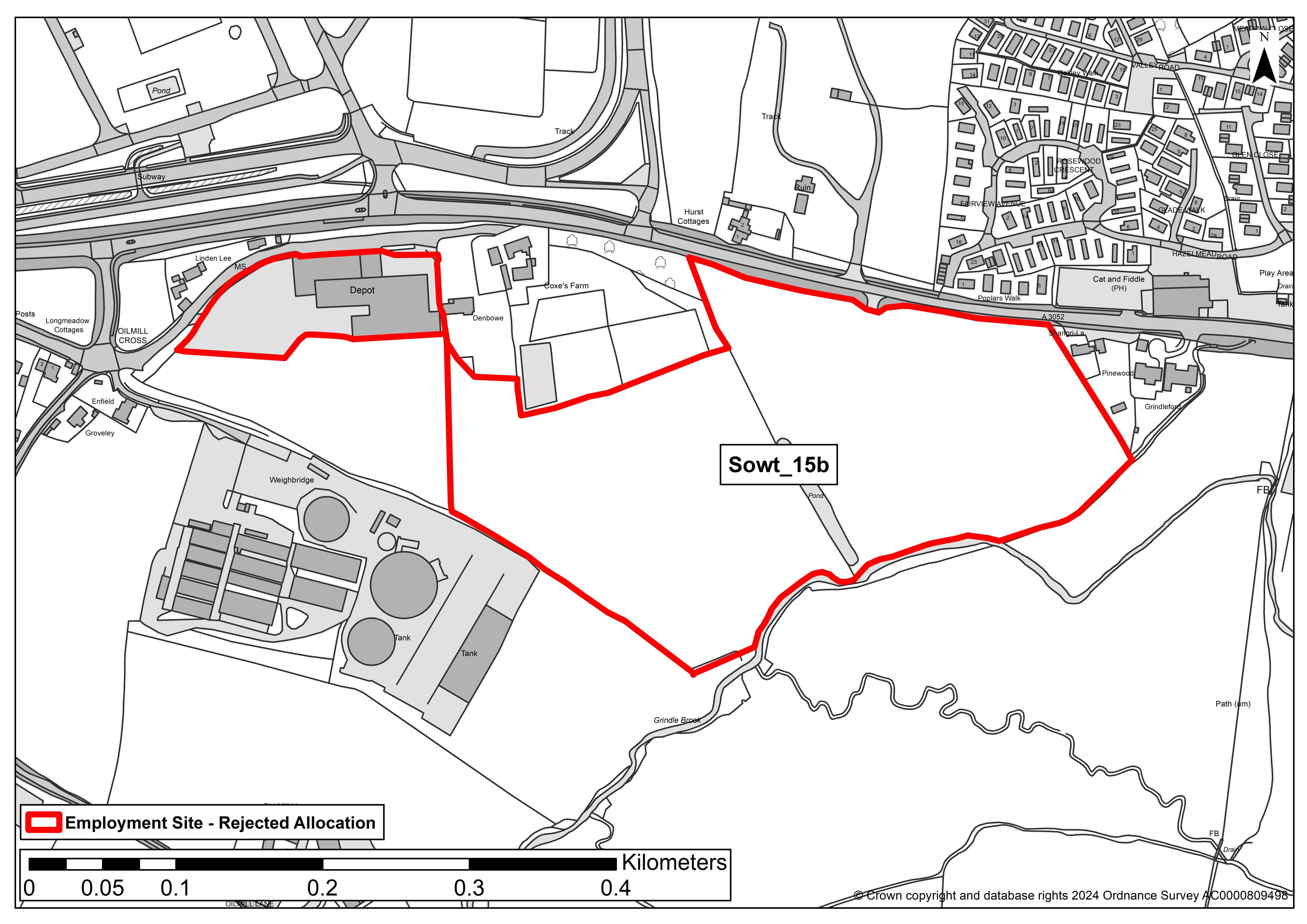
SITE ASSESSMENT SUMMARY AND CONCLUSION
Infrastructure
Existing business park with established access, limited in size, reasonable road collision record within vicinity.
Landscape
The sensitivity varies across the site and increases to the east. Any development should be restricted to the west of the site, between Langdon's Business Park and the commercial buildings to the south. Visual impact will be significantly increased if a new access onto A3052 is required. The development boundaries should be landscaped with a hedge of native species and a strip of woodland to soften the transition between the remaining field and new development.
Historic environment
Medium sensitivity - No significant effects which cannot be mitigated. An impact is predicted, but would not compromise the asset(s) cultural heritage value to the extent that the attributes that led to its designation, or ability to understand or appreciate its value, are diminished or compromised. Mitigation may make the impact acceptable, this is likely to be in the form. The overall significance of the asset would not therefore be materially changed.
Ecology
Minor adverse effect predicted (not significant)
Accessibility
The site lies around 400m from Clyst St Mary, adjacent to an existing business park with established access and close to a pub, an exhibition centre and a residential caravan park. Bus stop within easy walking distance (although there is limited pavement).
Other constraints
Protected trees lie within and in the boundary of the site. These would require protection.
Within Green Wedge in adopted Local Plan 2013-31 or made Neighbourhood Plan?
No
Opportunities
The existing business park could be extended, providing an opportunity for existing businesses to expand.
Yield (hectares of employment land)
8.55ha
Contribution to spatial strategy
Site is located in the countryside but within walking/cycling distance of a tier 4 settlement. Adjoins existing business park.
Should the site be allocated?
No
Reasons for allocating or not allocating
The site is reasonably well located adjacent and opposite development, close to facilities and public transport. It could function as an expansion to the existing business park. Development of the whole site would be excessive and inappropriate visually, it could also affect heritage assets. Restricting development to the western section of the site would be more appropriate, although the design would need to protect existing trees and an archaeological assessment would be required. Part of the site is proposed for allocation. Sowt_15b is not considered suitable for allocation due to it’s excessive scale in comparison to the existing active employment uses already in place. The visual landscape impact, the impact on heritage assets and biodiversity are higher in this part of the site than on the section proposed for allocation.
If whole site is not suitable for allocation, could a smaller part be allocated?
Yes – 1ha of the originally submitted Sowt_15 site is proposed for allocation as Sowt_15a.None of this remaining part (Sowt_15b) of the site is considered suitable for allocation.
Wood_31
SITE DETAILS
Location: Adjoining Woodbury Business Park
Reference number: Wood_31
Site area (ha): 5.5
Address: Land Adjoining Woodbury Business Park, Woodbury, EX5 1AY
Proposed use: Employment
SITE MAP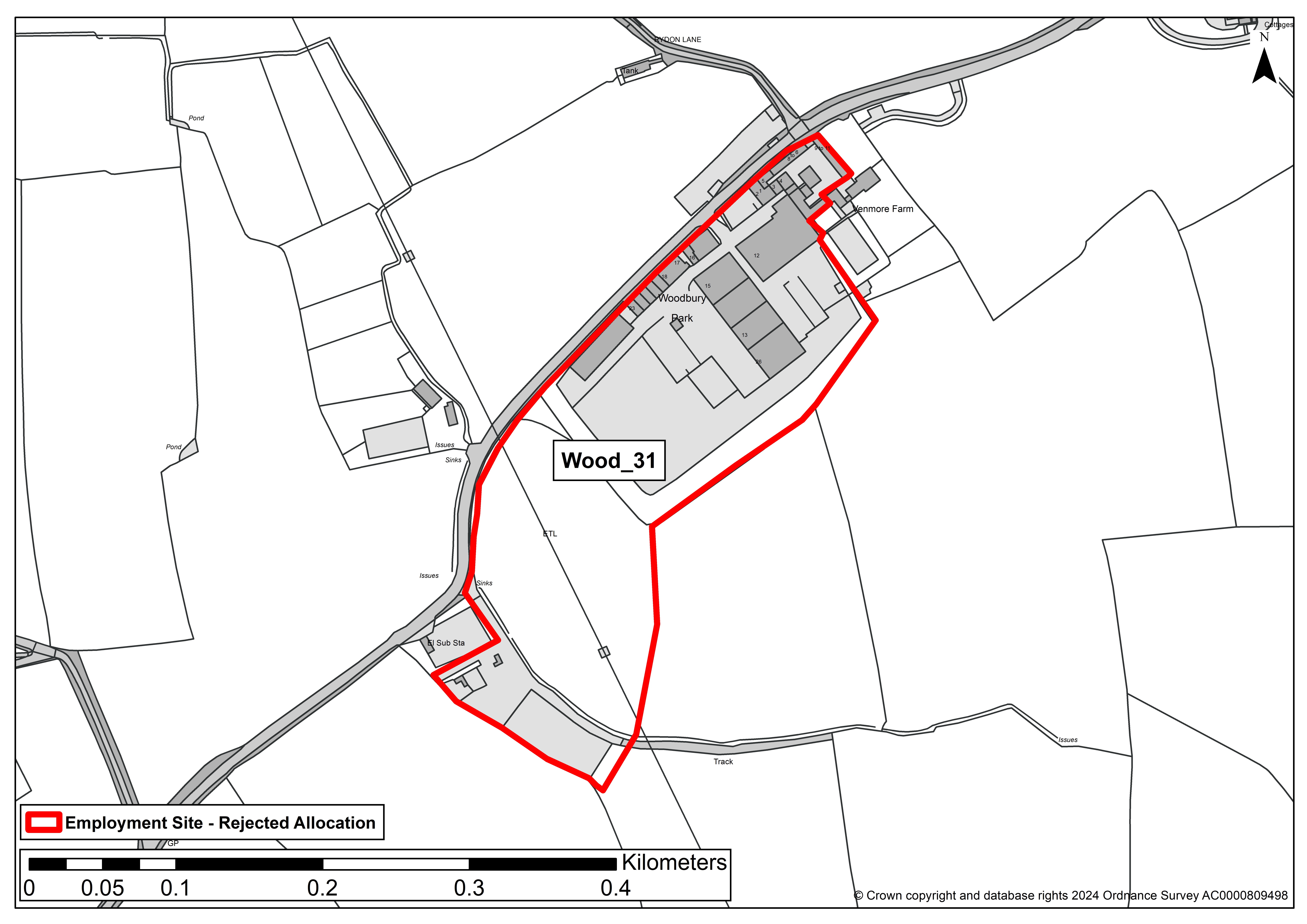
SITE ASSESSMENT SUMMARY AND CONCLUSION
Infrastructure
Devon County Council Highways: A3052/A376 Sites - The highway network already has capacity issues, there are limited public transport options and distance from the main attractors is beyond most walking and cycling distance. There are numerous sites in the vicinity and they need to be considered in a comprehensive masterplan and access strategy. In addition the site is remote from other development and facilities with poor ped/cycle links. Middle and outer zone of high pressure gas pipeline covers western part of site, which has been excluded from site area to end up with a yield of 2.3 ha.
Landscape
Gently rolling portion of larger field in arable cultivation. Bounded by historic hedgerow on north west, and west boundary. Woodbury Business Park is adjacent to the north, bounded by modern planting. Elsewhere, fields surround the site, with a single carriageway road adjacent to north west. On-site high voltage electricity mast and pylons, with an electricity sub station adjacent to west. Overall, medium landscape sensitivity to development.
Historic environment
Grade II listed Venmore Farm is around 110m from NE edge of the site. The intervening Woodbury Business Park, existing mature trees to the south of the Grade II listed Venmore Farm, and distance (over 100m) all limit/obscure views between the site and the listed building. There is a post-medieval to modern extraction pit in the northern part of the site close to the road. Overall, Low: no concerns identified on current evidence, although archaeological mitigation measures may be required.
Ecology
Large, arable field within Exe Estuary and Pebblebed Heaths habitat mitigation zones, but the proposed use for employment development means a limited effect compared to residential. Minor adverse effect predicted (not significant).
Accessibility
Eight out of 12 facilities within 1,600m of site. However, as of October 2022, bus services are no longer stopping at the bus stops adjacent to Woodbury Business Park. With no footpath, car travel is the only realistic means of travel for people travelling to work at the site, and to access facilities elsewhere.
Other constraints
Grade 3 agricultural land. Slither of 1/30 year surface water flood risk crosses W part of site. Site includes existing business park which has been removed from final yield.
Within Green Wedge in adopted Local Plan 2013-31 or made Neighbourhood Plan?
No
Opportunities
None identified.
Yield (hectares of employment land)
2.3
Contribution to spatial strategy
Extension of existing business park in a countryside location, where the emerging spatial strategy does not support development.
Should the site be allocated?
No
Reasons for allocating or not allocating
Site is of a significant scale in a countryside location that is only accessible by private car, with no public transport service or walking/cycling potential to access the site. In addition, medium landscape sensitivity to development. The relatively limited employment land need alongside these constraints means that this site should not be allocated.
If whole site is not suitable for allocation, could a smaller part be allocated?
No
Wood_38
SITE DETAILS
Location: Adjoining Greendale Business Park
Reference number: Wood_38
Site area (ha): 72.1
Address: Greendale Business Park, Sidmouth Road, Woodbury Salterton, Exeter, EX51EX
Proposed use: Employment/Mixed use
SITE MAP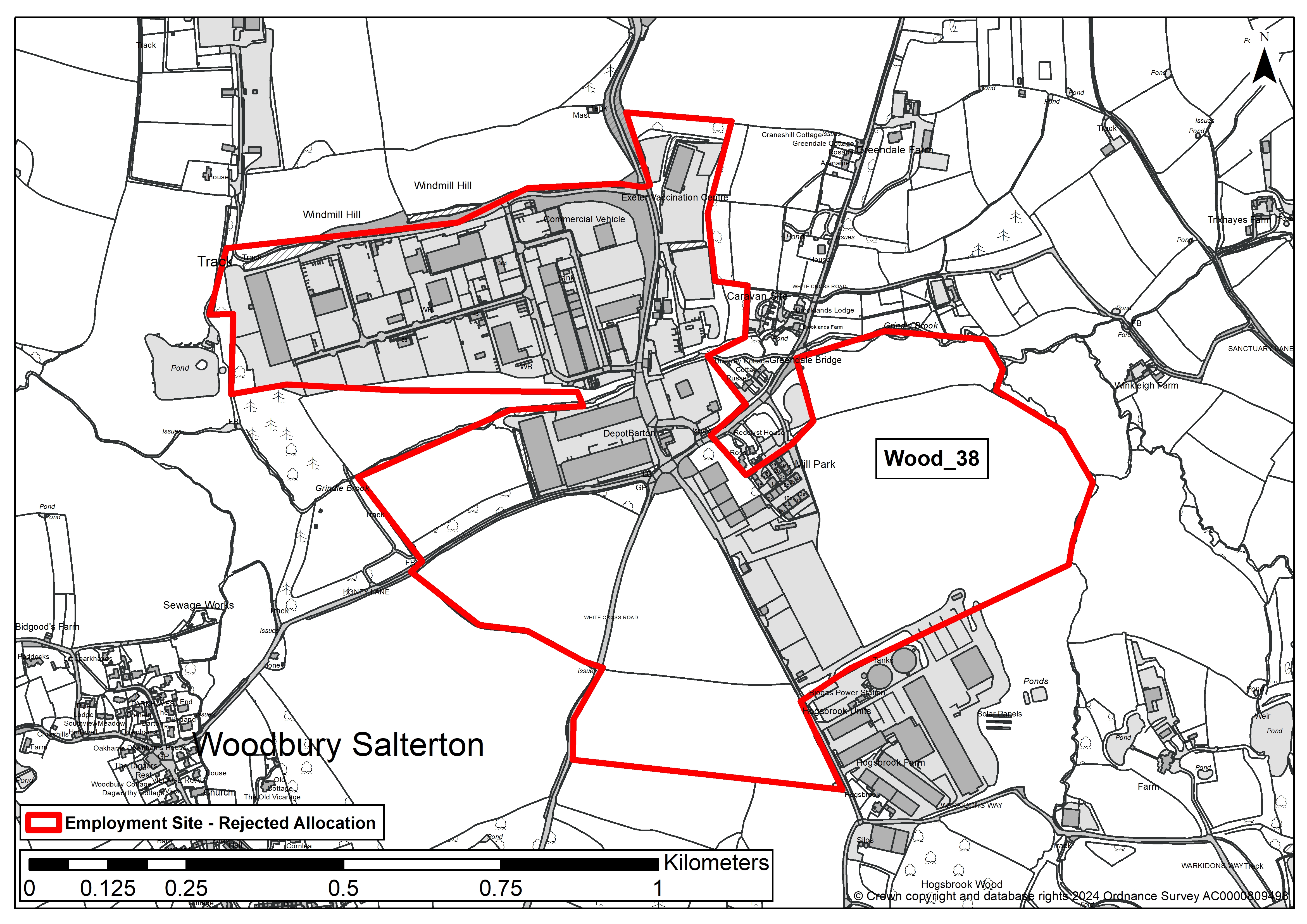
SITE ASSESSMENT SUMMARY AND CONCLUSION
Infrastructure
A3052/A376 Sites - The highway network already has capacity issues, there are limited public transport options and distance from the main attractors is beyond most walking and cycling distance. There are numerous sites in the vicinity and they need to be considered in a comprehensive masterplan and access strategy
Landscape
Medium sensitivity - Limited sense of the site from the A3052 to the north, but views from the access road quickly become apparent showing the extensive existing business park in the foreground and fields beyond. There are open views of the site from lane (Warkidons Way) to the south, which show the built form of the existing business park set lower down the valley, along with Hogsbrook Farm buildings to east, surrounded by rural context of agricultural fields rising to the south. Similar findings for view along White Cross Road and Honey Lane - predominantly rural context, with the presence of existing business park in views to the north.
Historic environment
Medium sensitivity - No significant effects which cannot be mitigated. An impact is predicted, but would not compromise the asset(s) cultural heritage value to the extent that the attributes that led to its designation, or ability to understand or appreciate its value. Grade II listed Greendale Barton is located in the centre of the site, on the southern edge of the existing business park. Grade II listed Brooklands Farm is around 30m from edge of site in north west mature trees obscure views into the site, but potential impact upon this asset.
Ecology
Minor adverse effect predicted (not significant)- Several TPOs cover parts of the site. Hogsbrook Farm County Wildlife Site located 131m to south.
Accessibility
The site is within 1,600 metres of 4 or more different local facilities and within 1,600 metres of a train station or bus route with an hourly or better service.
Other constraints
Northern tip of site may contain Grade 2 agricultural land, but the remainder is Grade 3. A slither of Flood zone 3 and high surface water flood risk bisects the central part of the site, east to west. Flood risk also present on western and eastern fringes. Most of site, except southern and eastern edge, is within waste consultation zone. No overhead high voltage electricity lines. High pressure gas pipeline and related easement lies beneath 26.8 Ha of site. Also 24.5 Ha on land with existing employment development. Discount 51.3 Ha to reduce gross development area to 20.8 hectares. Southern part of site is within (outer) water protection zone.
Within Green Wedge in adopted Local Plan 2013-31 or made Neighbourhood Plan?
No
Opportunities
None identified
Yield (hectares of employment land)
20.8
Contribution to spatial strategy
The site is in open countryside, however it incorporates an existing business park and some of the site therefore adjoins it.
Should the site be allocated?
No
Reasons for allocating or not allocating
Countryside location and landscape impact is a concern. Probably unachievable on the whole site due to the position and extent of the HSE High Pressure Gas pipeline and its safeguarding zones across the central/ eastern part of the site, plus the amount of land within the Flood Zone.
If whole site is not suitable for allocation, could a smaller part be allocated?
No. The site as submitted is substantial. Areas adjoining the business park are unsuitable for allocation due to the various constraints which restrict/impact upon the potential developable area (in particular landscape impact, flooding and the safeguarding area associated with the high pressure gas pipeline).
This engagement phase has finished

...