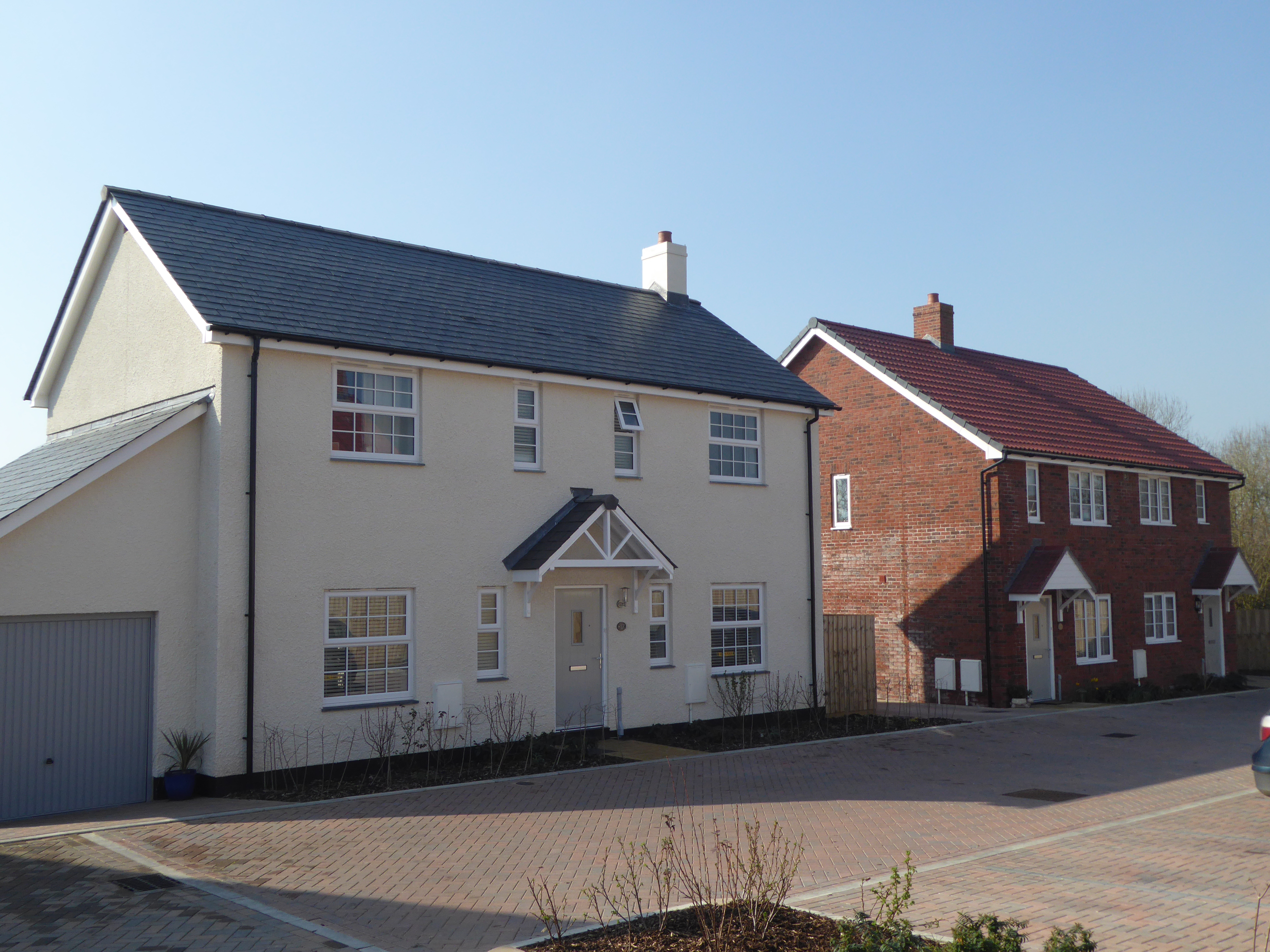
Home
New Housing and Mixed Use Site Allocations
New Housing and Mixed Use Site Allocations
One of the most important aspects of producing a Local Plan is allocating sites for new development. To ensure we have a clear approach on how we consider sites, we have published a Site Selection Methodology and are taking all potential sites through this process.
Under this process, first we identify a ‘long list’ of sites (Stage 1), then sift out sites that are unreasonable (Stage 2), only assessing in more detail those sites with a reasonable prospect of being allocated (Stage 3).
Finally, based upon a combination of the site assessment, Local Plan spatial strategy, and district-wide housing/employment requirement, we select which sites to allocate, and not, with reasons why (Stage 4).
The Draft Local Plan consultation took place from November 2022 to January 2023 and contained numerous housing (and employment) sites for consultation as either ‘preferred’, ‘second choice’, or ‘rejected’.
During consultation, a total of 38 additional housing sites were submitted. Most of the sites were sifted out (Stage 2 in the methodology) for reasons including lack of evidence from the landowner on land availability, overlap with existing sites, and being located in a rural location (i.e. not within or adjacent to settlements in Tiers 1-4 of the settlement strategy, and not offering potential to be a new settlement).
The site sifting resulted in a total of 12 new sites, plus a site at Seaton (Seat_13a) that was not previously consulted on. A ‘summary’ site assessment has been prepared for these sites, with further detailed assessment on landscape, historic environment and ecology to be undertaken following public consultation.
Overview of Housing and Mixed-use site allocations for consultation
Settlement | Site ref. | Address | No. dwellings | Allocate?
|
Axminster | The Co-operative Food, West Street, Axminster, | 15 | No – rejected | |
Axminster | Land at Millwey Chard Road, Axminster, | 19 | Yes – preferred | |
Axminster | Millwey Garages, St Andrews Drive, Axminster, EX13 5EZ | 6 | Yes – preferred | |
Axminster | Websters Garage, | 10 | Yes – preferred | |
Axminster | Land West of Prestalier Farm, Beavor Lane, Axminster | 29 | Yes – preferred |
Click on the site reference in the table above for further information
Settlement | Site ref. | Address | No. dwellings | Allocate?
|
Beer | Land at Quarry | 35 | No – rejected |
Click on the site reference in the table above for further information
Settlement | Site ref. | Address | No. dwellings | Allocate?
|
Plymtree | Land West of the Village Hall | 43 | No – rejected |
Click on the site reference in the table above for further information
Settlement | Site ref. | Address | No. dwellings | Allocate?
|
Seaton | Land adjacent to Axe View Road, Seaton, EX12 2JT | 39 | Yes – preferred |
Click on the site reference in the table above for further information
Settlement | Site ref. | Address | No. dwellings | Allocate?
|
Tipton St John | Combe Bank | 29 | No – rejected |
Click on the site reference in the table above for further information
Settlement | Site ref. | Address | No. dwellings | Allocate?
|
Western side | Land at Mosshayne Lane, | 1,000 | Yes - second |
Click on the site reference in the table above for further information
Settlement | Site ref. | Address | No. dwellings | Allocate?
|
Woodbury | West of Wood_10 | 23 | No – rejected |
Click on the site reference in the table above for further information
These sites cover both Housing and Mixed Use (housing, employment and other uses).
As the tables show, a total of six sites are ‘preferred’ allocations for housing, totalling some 123 dwellings; with six sites totalling 165 dwellings not preferred for allocation.
In addition, a second choice’ site of approximately 1,000 dwellings is Brcl_31a, a large site adjacent to the boundary of the M5. This site was submitted by a national housebuilder in consultation on the Draft Local Plan.
Although the housebuilder said the consultation response was prepared on behalf of the landowners, it subsequently came to light that the landowner for the south-east part of the site was not interested in making their land available for development.
Another key issue is it appears that highways access from the B3181 to the north is required over land that is owned by National Highways, who emphasise that "…our estate cannot be considered as being available for third party development and alternative access proposals should be explored. National Highways would request this is made clear in any public consultation."
The housebuilder has said they intend to discuss this with National Highways, with the aim of resolving any issues prior to publication of the Regulation 19 Local Plan. This Regulation 18 Further Consultation may also provide further detail on these issues.
Please note we are only seeking comments on these sites. We are not requesting new sites to be submitted.
Summary findings
The map below shows the location of sites that were assessed.
The detailed site assessments that follow starts off with the large strategic site at Mosshayne Lane, Pinhoe (east of M5) and then site ordering follows the hierarchy of settlements as set out in the draft East Devon Local Plan.
Firstly, Exmouth as the Principal Centre, then the Main Centres, followed by the Local Centres and Service Villages (see Strategic Policy 1 of the consultation draft local plan).
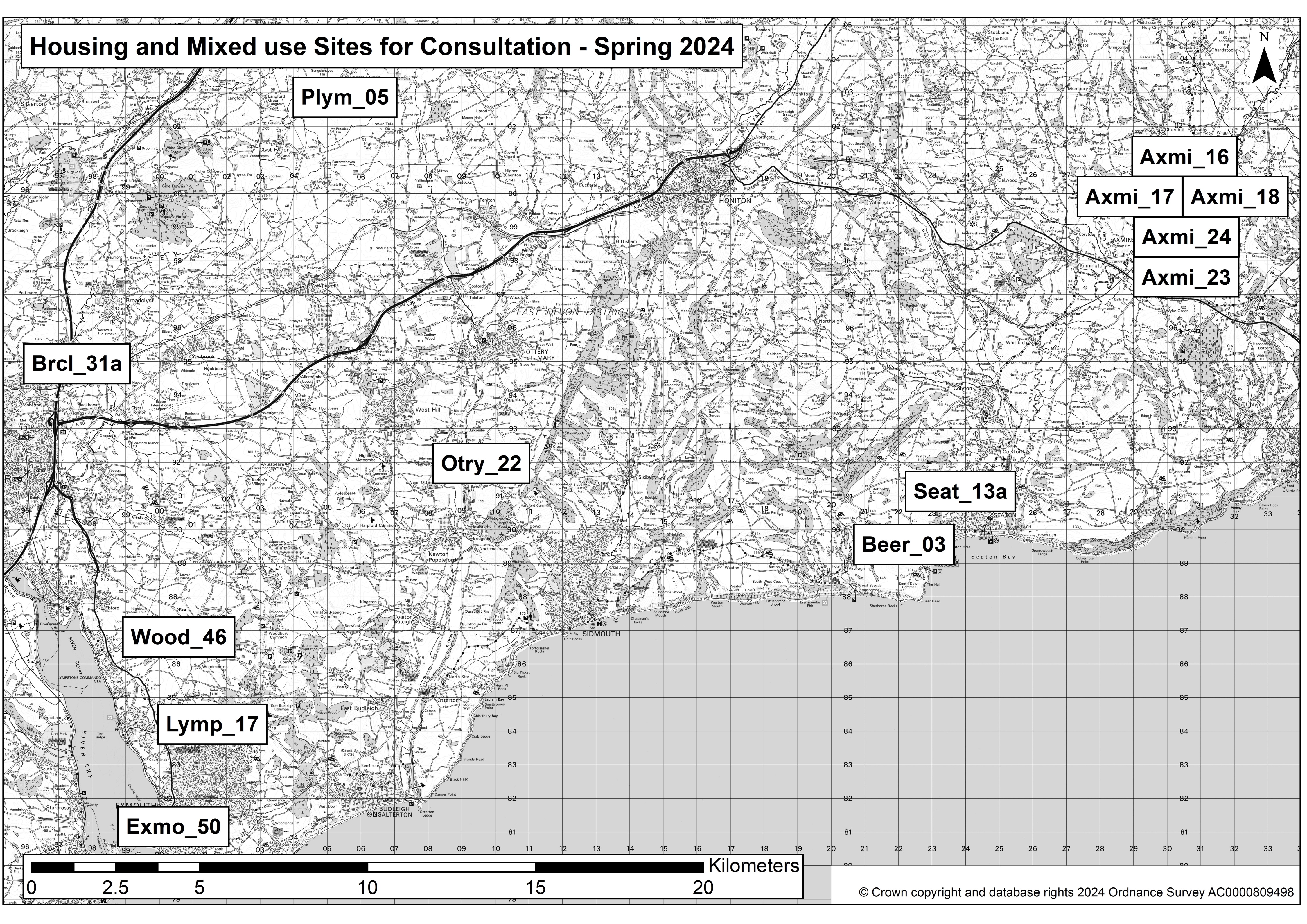
Click here for a responsive map
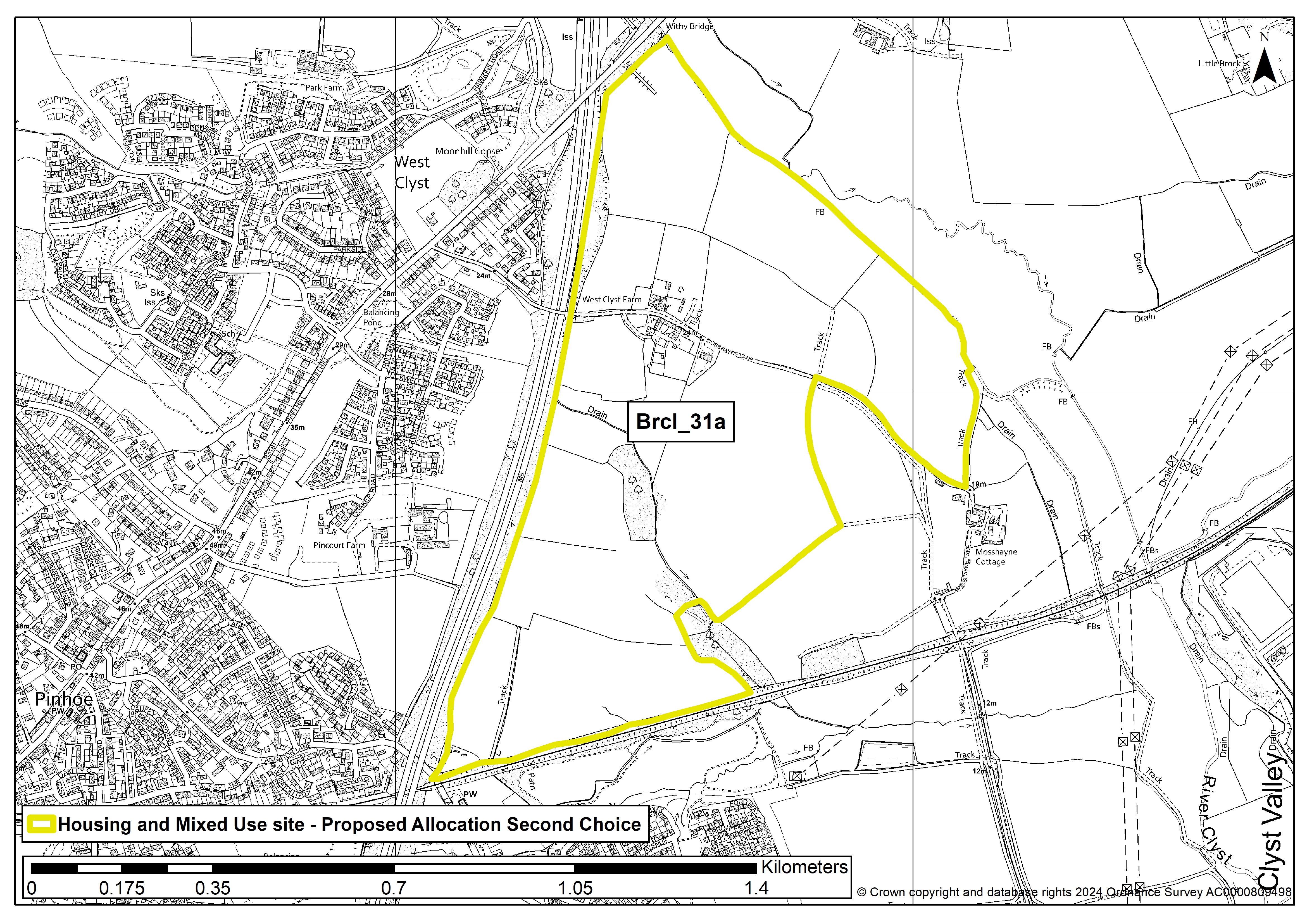
Brcl_31a
SITE DETAILS
Settlement: Land at Mosshayne Lane, Pinhoe (east of M5)
Reference number: Brcl_31a
Site area (ha): 68.78
Address: Land at Mosshayne Lane, EX1 3TR
Proposed use: Residential plus related uses
SITE MAP
SITE ASSESSMENT SUMMARY AND CONCLUSION
Infrastructure
Full spectrum of facilities expected including Community Hall, GP practice, Primary School, Secondary School, Public Houses, Shops, Post Office & Stores, Open Spaces, and Play Areas.
Clarification is needed regarding the access point off the B3181 at the northern end of the site.
The Barratt Homes / David Wilson Homes Regulation 18 representation states: "The majority of the development would be accessed via a spine road from the B3181, with the smaller residential parcels in the south western part of the site accessed from Langaton Lane.
"It is therefore considered that any concerns from the highway authority can be suitable addressed and mitigated through an alternative access strategy."
However, National Highways owns land that includes a ransom strip to this access point and a representative on their behalf has since told EDDC: "I would like to emphasise that our estate cannot be considered as being available for third party development and alternative access proposals should be explored. National Highways would request this is made clear in any public consultation."
The housebuilder has said they intend to commence discussions with National Highways shortly, with the aim of resolving any issues prior to publication of the Regulation 19 Local Plan.
Landscape
Medium sensitivity - This large site of mainly undeveloped fields has the M5 and the new developments at Pinn Court Farm & Moonhill Copse to the west, the Exeter-Waterloo trainline and the new development at Tithebarn to the south and Exeter Logistics Park & Skypark to the south-east.
Historic environment
Medium sensitivity - There is a Grade II listed building on the site (West Clyst Farm on Mosshayne Lane), but this is already surrounded by a small development and the proposals state that the existing lane would be maintained.
Ecology
Minimal ecological impact provided trees and hedgerows are retained. The site includes an Unconfirmed Wildlife Site (Broadclyst Moor - Dymonds Bridge Marsh) but this could be incorporated into the Clyst Valley Regional Park. Overall, minor adverse effect predicted (not significant).
Accessibility
The site would require its own range of facilities, but it is currently within 1,600m of four or more facilities, including schools, a hall, and a pub.
The nearest primary school is currently Westclyst Community Primary School and nearest secondary school is Clyst Vale Community College. The nearest train station is Pinhoe (approximately 700m from the south-west corner of the site).
Other constraints
A total of 14.81ha falls within FZ3 (1%) and 20.22ha within FZ2 (0.1%) but these areas fall within the Clyst Valley Regional Park portion of the site.
Agricultural Land - Only a small pocket of the site (in the south-east) was classified in the post-1988 assessment (at Grade 2 and Grade 3b) but the 2002 strategic assessment work found the majority of the site to be Grade 1 (and Grade 3 in the north and along the boundary to the south-east of the site).
Noise issues that would affect the site will likely require mitigation – particularly from the M5 to the west and possibly also from the railway line to the south
Within Green Wedge in adopted Local Plan 2013-31 or made Neighbourhood Plan?
No
Opportunities
North-South trail (part of the Clyst Valley Regional Park Strategy), sports pitches, community facility, natural & semi-natural greenspace for biodiversity enhancements and green with play space.
Yield (number of dwellings)
Approximately 1,000 dwellings
Contribution to spatial strategy
Land at Mosshayne Lane is a sustainable location for new development, which would align with the Council’s overall spatial strategy.
The site is in close proximity to the extensive facilities and services available in Exeter, as well as other existing infrastructure in the vicinity of the site, including Pinhoe Railway Station to the south west and Exeter Science Park to the south.
The proposed development could facilitate a connection over the railway line, providing a link to these facilities.
Should the site be allocated?
Second choice
Reasons for allocating or not allocating
The site is being promoted by a national housebuilder who have stated they have the resource and expertise to deliver this development in full.
The proposed development would accommodate approximately 1,000 dwellings, land for educational use and extensive areas of public open space (including a country park), which would collectively represent a sustainable community that could benefit future and existing residents within the western part of East Devon.
If whole site is not suitable for allocation, could a smaller part be allocated?
N/A
Lymp_17
SITE DETAILS
Settlement: Exmouth
Reference number: Lymp_17
Site area (ha): 3
Address: Land south-west of Marley Hayes, Hulham Road, Exmouth EX8 5DZ
Proposed use: Residential
SITE MAP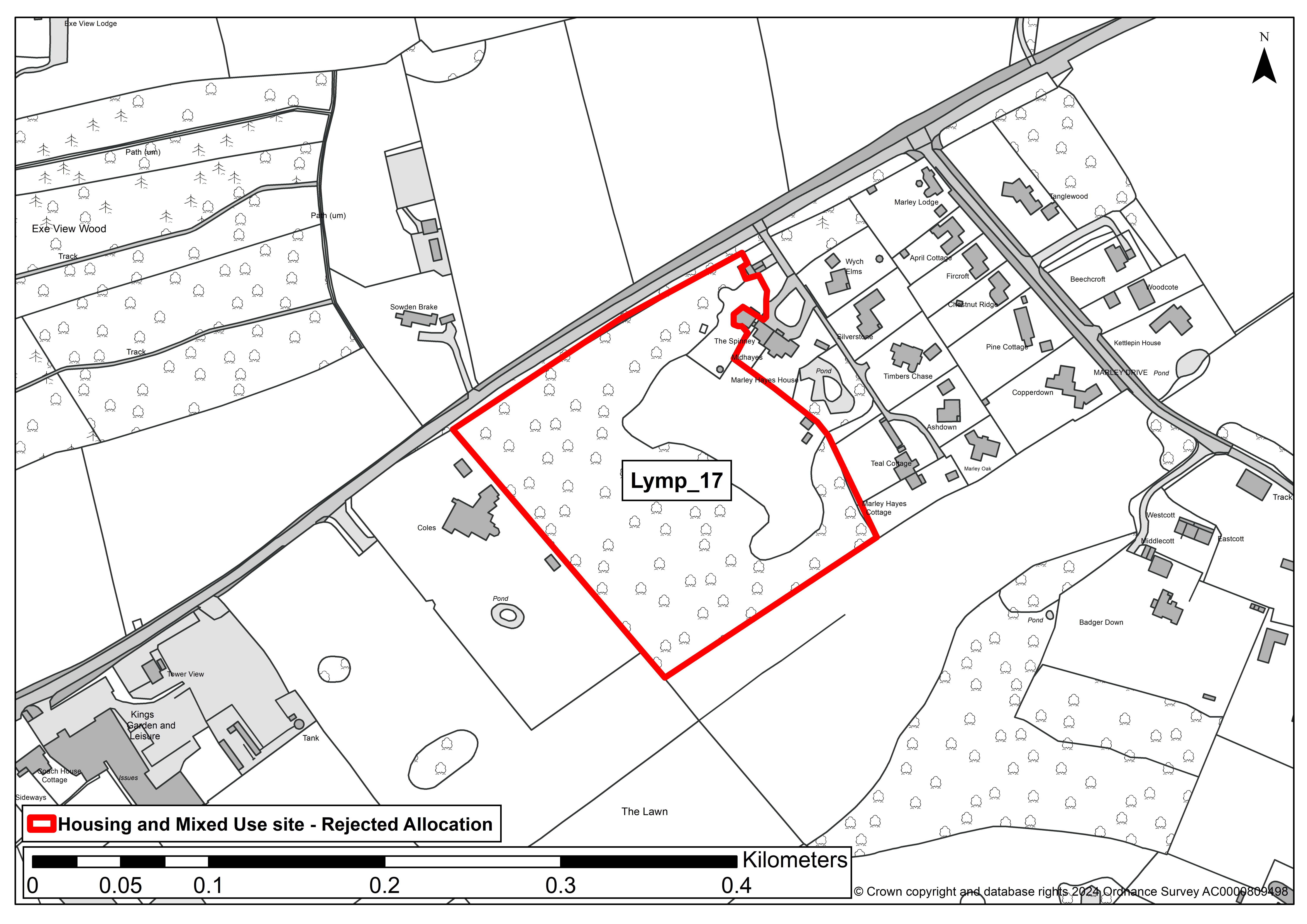
SITE ASSESSMENT SUMMARY AND CONCLUSION
Infrastructure
The site is being promoted with an access over a private road via a narrow junction onto Marley Road.
Without significant upgrading, involving substantial vegetation loss, it is suggested that it is highly unlikely that this junction could support anything more than minimal new development (perhaps nil development) and there would also be a need for widening of a narrow private lane.
If allocated the assumption is that access would need to be achieved via other proposed allocated land in this north-eastern part of Exmouth or perhaps a new access off Marley Road would be possible.
Landscape
The site is well screened with mature trees and vegetation to boundaries and within. The site has a quiet and quite remote countryside feel, in part because of maturity of surrounding vegetation, despite relative proximity to built development on its north-eastern edge.
There are many mature trees within the site that would need to be retained and adequately buffered - this would place significant limits on development potential. Overall, medium-high landscape sensitivity.
Historic environment
There are no listed buildings in close proximity of the site and nil or limited potential for adverse heritage impacts would be expected from development.
Overall, low sensitivity - No concerns on current evidence, although archaeological mitigation measures may be required.
Ecology
The site comprises of what would appear to be non-improved grassland with a substantial number of mature trees within the site and to its boundaries.
A number of these trees are subject to Tree Preservation Orders. As such there will be significant local wildlife value at the site.
The site is an Unconfirmed County Wildlife site. Overall, significant moderate adverse effect predicted.
Accessibility
The site falls within 1,600 metres of a range of services and facilities.
Other constraints
No additional constraints are noted.
Within Green Wedge in adopted Local Plan 2013-31 or made Neighbourhood Plan?
No
Opportunities
No specific opportunities are noted.
Yield (number of dwellings)
20
Contribution to spatial strategy
Exmouth is the Principal Centre in East Devon and should therefore see significant development to serve its own needs and that of the wider surrounding areas.
Should the site be allocated?
No
Reasons for allocating or not allocating
Based specifically on wildlife value of the site and concerns around acceptability of highway access the site should not be allocated for development.
If whole site is not suitable for allocation, could a smaller part be allocated?
No
Exmo_50
SITE DETAILS
Settlement: Exmouth
Reference number: Exmo_50
Site area (ha): 0.55
Address: Disused police station
Proposed use: Residential
SITE MAP
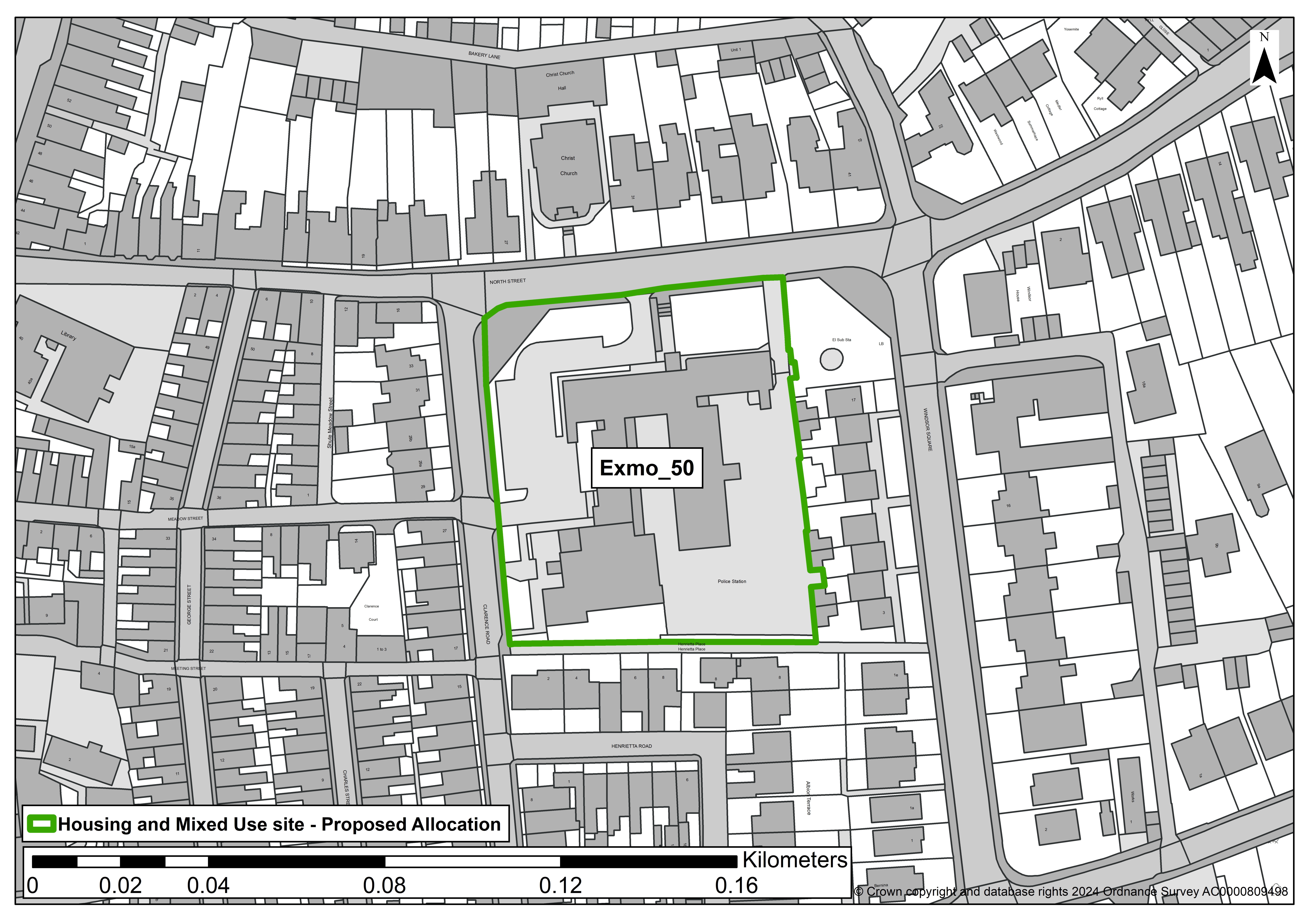
SITE ASSESSMENT SUMMARY AND CONCLUSION
Infrastructure
From officer assessment there is no evidence to suggest that there are technical constraints that would inhibit re-development for housing.
Landscape
This site sits in an urban area of Exmouth, close to the town centre and surrounded by built development, predominantly in residential use.
Landscape sensitivity is considered to be low and potential for adverse landscape impacts has been screened out.
Historic environment
The land around the police station site forms one of the core historic areas of development of Exmouth.
Late 19th Century Ordinance Survey mapping shows an already built-up residential urban fabric in this part of the town and the site itself, referenced as Branswick Square on historic mapping, can be assumed to have been a formal green urban square to what were, and predominantly remain, substantial residences (a few split into flats) fronting on to, and near to, the site/the square.
The existing police station building (understood to become redundant in its current form) is a post second world war Modernist informed development of some 20th Century historic interest.
There are a significant number of Grade II listed residential properties, mostly dating from the early/mid 19th Century, that are at and around the site boundaries.
The sites past use and history plus the relevance of surrounding assets can form a positive cue to inform a well designed and implemented scheme that offers scope for enhancement of the setting of the assets. Overall, medium: no significant effects which cannot be mitigated.
Ecology
There are no designated wildlife sites at or in close proximity of the site. The site is currently occupied by a police station building built in the latter half of the 20th century.
There are limited formal green spaces around the existing building and a small number of existing trees on site. Overall, minor adverse effect predicted (not significant).
Accessibility
The site falls within 1,600 metres of a range of services and facilities, it is close to Exmouth town centre and has good access to public transport.
Other constraints
No additional constraints are noted.
Within Green Wedge in adopted Local Plan 2013-31 or made Neighbourhood Plan?
No
Opportunities
No specific opportunities are noted.
Yield (number of dwellings)
20
Contribution to spatial strategy
Exmouth is the Principal Centre in East Devon and should therefore see significant development to serve its own needs and that of the wider surrounding areas.
Should the site be allocated?
Yes
Reasons for allocating or not allocating
The site occupies an urban residential location and the existing police station building is understood to be redundant.
Devon and Cornwall Police have advised of their intent to submit a planning application for the redevelopment of the site to include a new police station and for 0.4 hectares of the site to accommodate residential development.
The site falls within the Exmouth Conservation Area and there are a large number of Grade II listed residential buildings close to the site and on its northern and western edges directly fronting on to the site.
There is, therefore, significant heritage interest that any redevelopment will need to be especially sensitive to.
The police station building itself is representative of a period of post Second World War Modernist informed architecture, that is increasingly being lost, and as such is of some interest.
The site does present a good opportunity for sensitive redevelopment to include residential uses.
If whole site is not suitable for allocation, could a smaller part be allocated?
Yes - In line with Devon and Cornwall Police aspirations around 0.4 hectares of the site would form a reasonable allocation element for residential uses.
Axmi_16
SITE DETAILS
Settlement: Axminster
Reference number: Axmi_16
Site area (ha): 0.2
Address: The Co-operative Food, West Street, Axminster, EX13 5PA
Proposed use: Residential
SITE MAP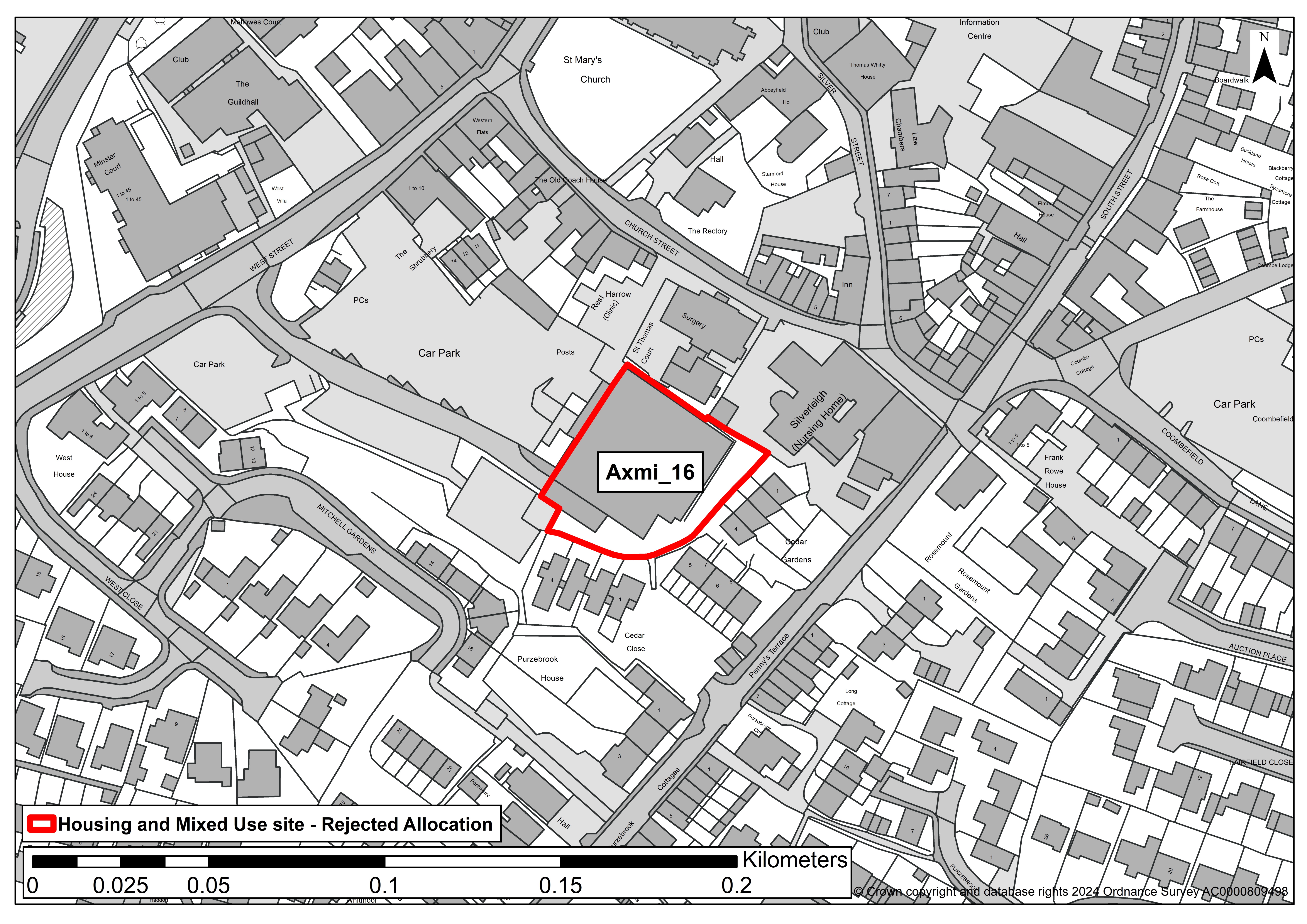 SITE ASSESSMENT SUMMARY AND CONCLUSION
Infrastructure
Devon County Council Highways advise that there is an existing private access into this brownfield site that also serves private car parks and is already subject to regular levels of vehicle movement.
It is also close to local amenities and well served by public footways.
Devon County Council Education advise that there is capacity for secondary places at Axe Valley School, but it may be difficult to extend primary school provision to accommodate housing levels beyond those set out in current local plan.
Landscape
Low sensitivity - Site comprises a food store in an urban setting.
Historic environment
Medium sensitivity - No significant effects which cannot be mitigated.
Ecology
The site is within 50 metres of a potential nature recovery network (grassland) and a habitat of principle importance (a small stream).
Minor adverse effect predicted (not significant). The site is within the River Axe Special Area of Conservation nutrient catchment zone and would need to deliver nutrient neutral development .
Accessibility
The site is within the town centre and 1,600 metres of at least nine different types of services and facilities, including a GP practice, community hall, post office, pubs, shops, primary and a secondary school.
Axminster train station is within 350 metres and the site is closet to a bus route with an hourly service.
Other constraints
The site is adjacent to an area of potentially contaminated land.
Within Green Wedge in adopted Local Plan 2013-31 or made Neighbourhood Plan?
No
Opportunities
None identified
Yield (number of dwellings)
15
Contribution to spatial strategy
The emerging local plan spatial strategy promotes significant development to the main centres of East Devon, including Axminster as a 'Tier 2' settlement. Axminster has a good range of facilities including a train station and secondary school.
In principle, Axminster is considered to be a good location for additional housing and employment growth within the plan period.
Should the site be allocated?
No
Reasons for allocating or not allocating
The site is located within the proposed town centre and primary shopping area, where development should enhance the range and quality of town centre, shopping and leisure facilities.
Redevelopment of the site for housing would be incompatible with this as it would result in the loss of a supermarket.
If whole site is not suitable for allocation, could a smaller part be allocated?
No
Axmi_17
SITE DETAILS
Settlement: Axminster
Reference number: Axmi_17
Site area (ha): 0.95
Address: Land at Millwey, Chard Road, Axminster, EX13 5NL
Proposed use: Residential
SITE MAP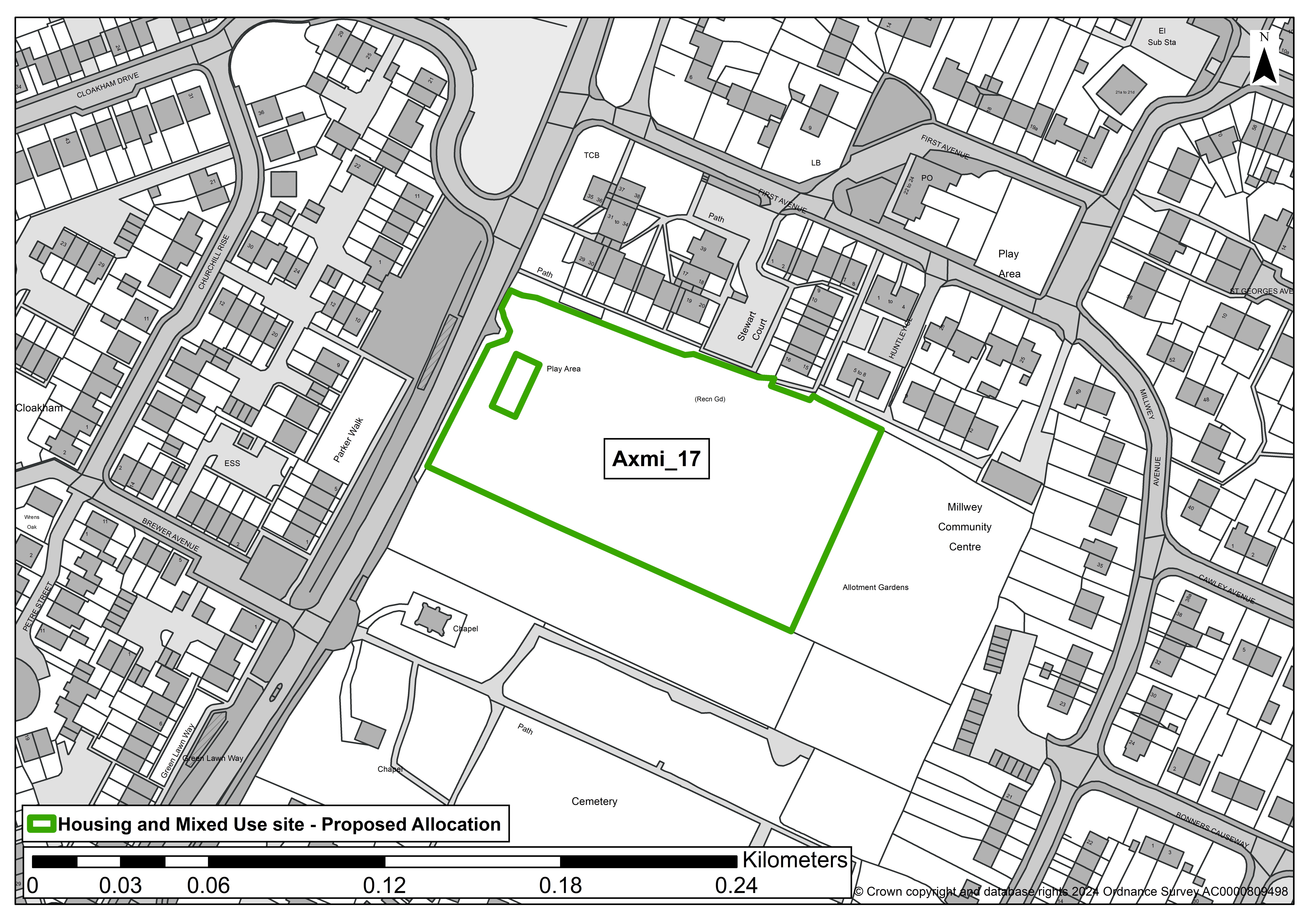 SITE ASSESSMENT SUMMARY AND CONCLUSION
Infrastructure
Devon County Council Highways advise that the site has good pedestrian accessibility with the existing access being in close proximity to a pedestrian crossing and opposite a bus stop. Access arrangements may require mitigation.
Devon County Council Education advise that there is capacity for secondary school places at Axe Valley School, but it may be difficult to extend primary school provision to accommodate housing levels beyond those set out in the current local plan.
Landscape
Medium sensitivity - Site forms a 'green' and visually 'open' space within the urban fabric of the town.
It is bounded by mature hedges, but views across the site are available form the field gate to Chard Road with filtered views through the hedge during the dormant season.
Historic environment
Low sensitivity - No concerns identified on current evidence, although archaeological mitigation measures may be required.
No impact upon an asset is predicted or, if an impact is predicted, the cultural heritage value of the asset(s) would be unaffected.
The Devon Historic Environment Record shows that the site formed part of a second world war United States military hospital.
Ecology
The site is a potential nature recovery network site (grassland). Minor adverse effect predicted (not significant). The site is within the River Axe Special Area of Conservation nutrient catchment zone and would need to deliver nutrient neutral development.
Accessibility
The site is within 1,600 metres of at least nine different types of services and facilities, including a GP practice, community hall, post office, pubs, shops, primary and a secondary school.
Axminster train station is within 1400 metres and the site is adjacent to a bus route with an hourly service. Pedestrian access to the town centre is possible along Chard Road.
Other constraints
A small section of the site is subject to flooding and will require further assessment. The site forms open space and was previously used for sports purposes.
Any potential for allocation for development would need to take into account the acceptability of open space loss and also the possible need for replacement provision of equal or greater benefit.
Within Green Wedge in adopted Local Plan 2013-31 or made Neighbourhood Plan?
No
Opportunities
The site is owned by the District Council so there is an opportunity to tailor housing to local priorities and to provide for other community needs
Yield (number of dwellings)
19
Contribution to spatial strategy
The emerging local plan spatial strategy promotes significant development to the main centres of East Devon, including Axminster as a 'Tier 2' settlement.
Axminster has a good range of facilities including a train station and secondary school. In principle, Axminster is considered to be a good location for additional housing and employment growth within the plan period.
Should the site be allocated?
Yes
Reasons for allocating or not allocating
As this site is an existing open space, with a previous use for sports pitches, it would need to be demonstrated that any net loss would be acceptable in planning terms taking into account, if relevant, potential replacement provision elsewhere.
The site is located within the existing urban fabric of the town and is well related to a very good range of services and facilities.
If whole site is not suitable for allocation, could a smaller part be allocated?
N/A
Axmi_18
SITE DETAILS
Settlement: Axminster
Reference number: Axmi_18
Site area (ha): 0.25
Address: Millwey Garages, St Andrews Drive, Axminster, EX13 5EZ
Proposed use: Residential
SITE MAP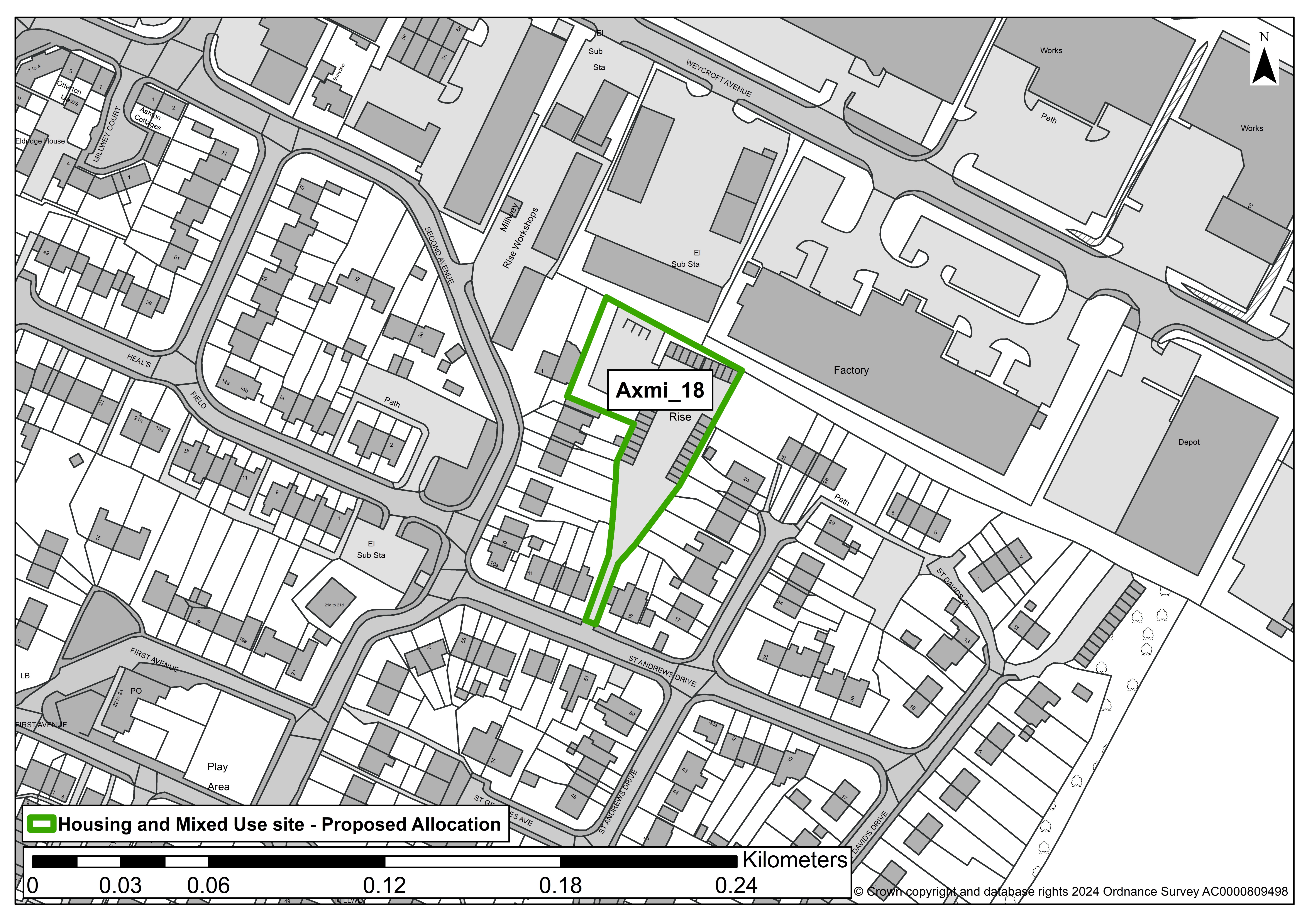
SITE ASSESSMENT SUMMARY AND CONCLUSION
Infrastructure
Devon County Council Highways advise that it is difficult to assess the access from desktop analysis but the visibility to the access may have its constraints due to existing surrounding infrastructure.
Devon County Council Education advise that there is capacity for secondary school places at Axe Valley School, but it may be difficult to extend primary school provision to accommodate housing levels beyond those set out in current local plan.
Landscape
Low sensitivity - The site comprises a garage court and parking area surrounded by housing and industrial buildings.
Historic environment
Low sensitivity - No concerns identified on current evidence, although archaeological mitigation measures may be required.
No impact upon an asset is predicted or, if an impact is predicted, the cultural heritage value of the asset(s) would be unaffected.
The Devon Historic Environment Record shows that the site formed part of a second world war United States military hospital.
Ecology
The site is within the River Axe Special Area of Conservation nutrient catchment zone and would need to deliver nutrient neutral development.
No other issues identified. Overall, minor adverse effect predicted (not significant).
Accessibility
The site is within 1,600 metres of at least nine different types of services and facilities, including a GP practice, community hall, post office, pubs, shops, primary and a secondary school.
Axminster train station is within 1,800 metres and the site is close to a bus route with an hourly service. Pedestrian access to the town centre is possible along Chard Road.
Other constraints
The access road is narrow and may be unsuitable for proposed development.
Within Green Wedge in adopted Local Plan 2013-31 or made Neighbourhood Plan?
No
Opportunities
Redevelopment of the site has the potential for environmental and visual enhancement of the local area.
Yield (number of dwellings)
6
Contribution to spatial strategy
The emerging local plan spatial strategy promotes significant development to the main centres of East Devon, including Axminster as a 'Tier 2' settlement.
Axminster has a good range of facilities including a train station and secondary school. In principle, Axminster is considered to be a good location for additional housing and employment growth within the plan period.
Should the site be allocated?
Yes
Reasons for allocating or not allocating
The site is located within the existing urban fabric of the town and is well related to a very good range of services and facilities.
If whole site is not suitable for allocation, could a smaller part be allocated?
N/A
Axmi_23
SITE DETAILS
Settlement: Axminster
Reference number: Axmi_23
Site area (ha): 0.28
Address: Websters Garage, 9 Lyme Street, Axminster, EX13 5AT
Proposed use: Residential
SITE MAP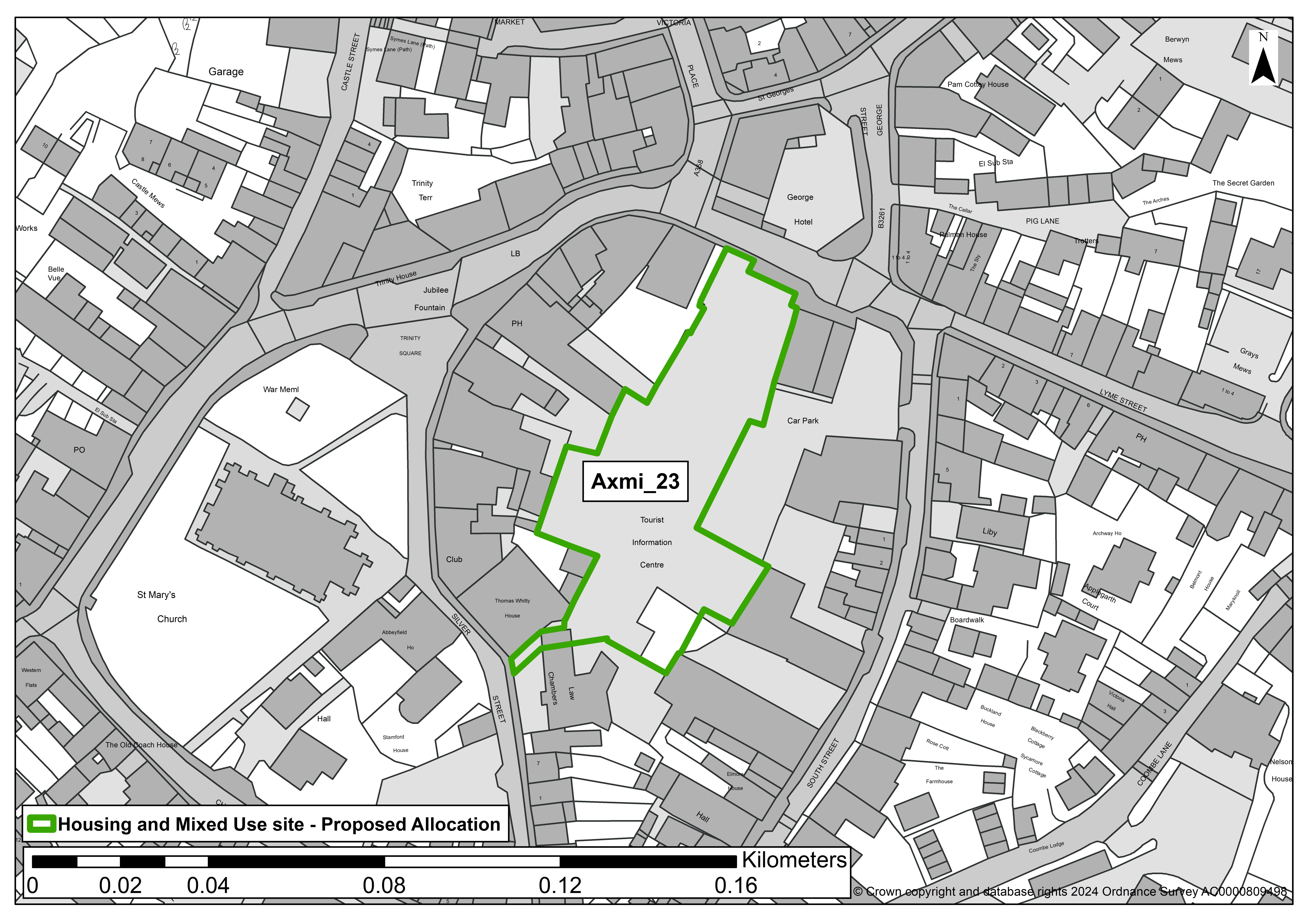
SITE ASSESSMENT SUMMARY AND CONCLUSION
Infrastructure
No Devon County Council Highways or Education comments available.
Landscape
Low sensitivity - Site of demolished buildings being used as a temporary surface car park but located in core of the historic town and surrounded by heritage assets.
Historic environment
The redevelopment of the site has the potential to affect the setting of several heritage assets.
Overall, medium - No significant effects which cannot be mitigated.
Ecology
The site is within the River Axe Special Area of Conservation nutrient catchment zone and would need to deliver nutrient neutral development.
It is also within 100 metres of a potential grassland nature recovery network (the Churchyard).
Although a 'significant moderate adverse effect is predicted' by the standard methodology due to the proximity of the churchyard, given the existing nature of the site (formerly developed site in use as a car park) a minor adverse effect predicted (not significant).
Accessibility
The site is within the town centre and is less than 1,600 metres from at least nine different types of services and facilities, including a GP practice, community hall, post office, pubs, shops, primary and a secondary school. Axminster train station is within 500 metres and the site is adjacent to a bus route with an hourly service.
Other constraints
Much of the site is potentially contaminated land. The site is in use as a public car park and is within the proposed town centre area.
Within Green Wedge in adopted Local Plan 2013-31 or made Neighbourhood Plan?
No
Opportunities
The site comprises an unsightly surface car park in the conservation area and surrounded by heritage assets.
Redevelopment of the site provides an opportunity to improve the visual appearance of the site and provide a mix of appropriate town centre uses, including an element of housing.
Yield (number of dwellings)
10
Contribution to spatial strategy
The emerging local plan spatial strategy promotes significant development to the main centres of East Devon, including Axminster as a 'Tier 2' settlement.
Axminster has a good range of facilities including a train station and secondary school. In principle, Axminster is considered to be a good location for additional housing and employment growth within the plan period.
Should the site be allocated?
Yes
Reasons for allocating or not allocating
The site is located within the existing urban fabric of the town and is well related to a very good range of services and facilities. Residential use is acceptable as part of a mixed use redevelopment scheme.
If whole site is not suitable for allocation, could a smaller part be allocated?
N/A
Axmi_24
SITE DETAILS
Settlement: Axminster
Reference number: Axmi_24
Site area (ha): 2.65
Address: Land West of Prestaller Farm, Beavor Lane, Axminster,
Proposed use: Residential
SITE MAP
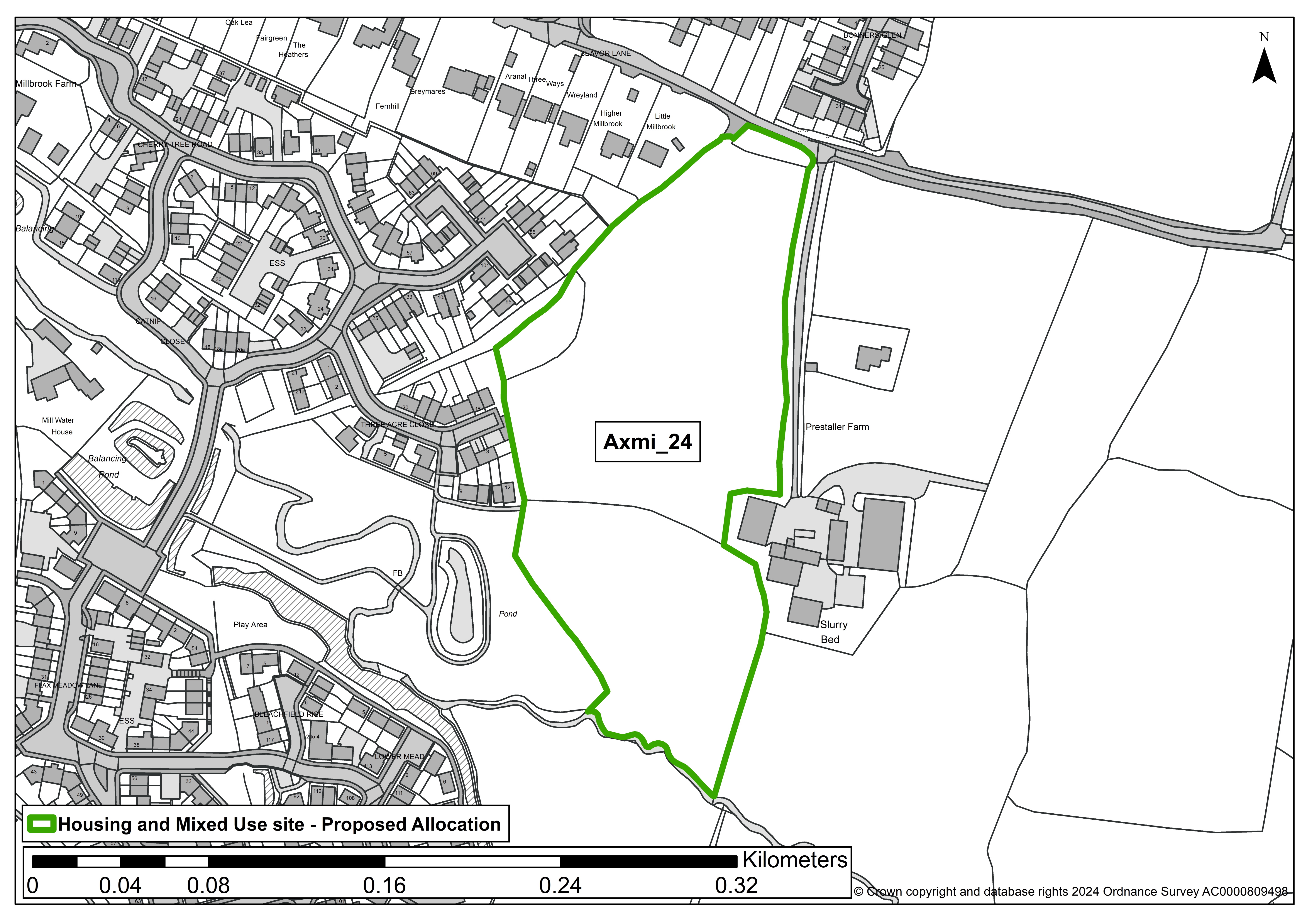
SITE ASSESSMENT SUMMARY AND CONCLUSION
Infrastructure
No Devon County Council Highways or Education comments available.
Landscape
Medium sensitivity – An ordinary landscape which is appreciated by the community but has little or no wider recognition of its value.
Historic environment
Low sensitivity - No concerns identified on current evidence, although archaeological mitigation measures may be required.
No impact upon an asset is predicted or, if an impact is predicted, the cultural heritage value of the asset(s) would be unaffected.
Ecology
The site is within the River Axe Special Area of Conservation nutrient catchment zone and would need to deliver nutrient neutral development. No other issues identified. Overall, minor adverse effect predicted (not significant).
Accessibility
The site is within 1,600 metres from at least nine different types of services and facilities, including a GP practice, community hall, post office, pubs, shops, primary and a secondary school.
Axminster train station is within 1,300 metres and the site is within 300 metres of a bus route with an hourly service.
Other constraints
None identified
Within Green Wedge in adopted Local Plan 2013-31 or made Neighbourhood Plan?
No
Opportunities
None identified
Yield (number of dwellings)
29
Contribution to spatial strategy
The emerging local plan spatial strategy promotes significant development to the main centres of East Devon, including Axminster as a 'Tier 2' settlement.
Axminster has a good range of facilities including a train station and secondary school. In principle, Axminster is considered to be a good location for additional housing and employment growth within the plan period.
Should the site be allocated?
Yes
Reasons for allocating or not allocating
The site is well connected to a range of services and facilities.
If whole site is not suitable for allocation, could a smaller part be allocated?
N/A
Seat_13a
SITE DETAILS
Settlement: Seaton
Reference number: Seat_13a
Site area (ha): 8.39
Address: Land adjacent to Axe View Road, Axe View Road, Seaton, EX12 2JT
Proposed use: Residential
SITE MAP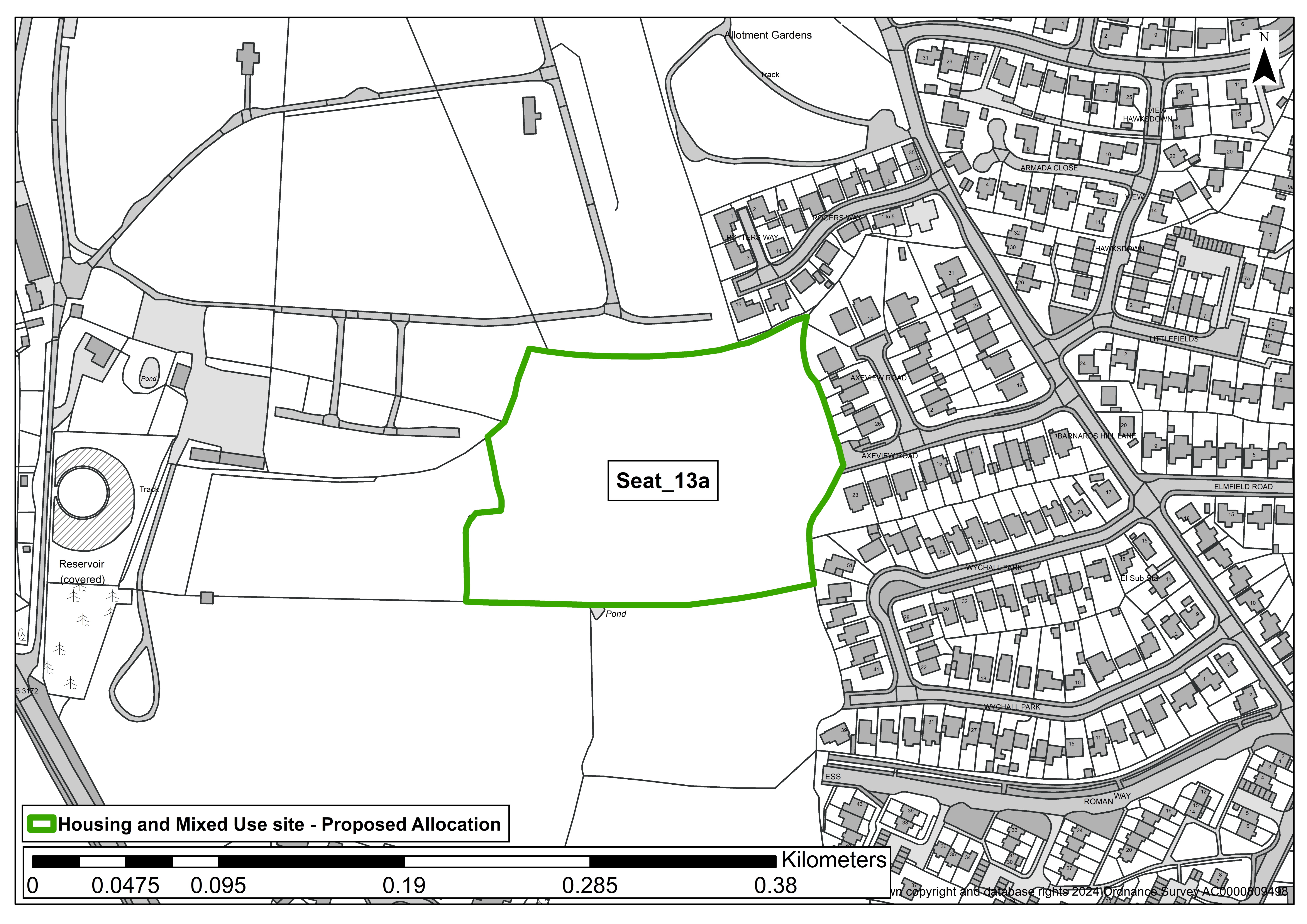
SITE ASSESSMENT AND SUMMARY
Infrastructure
Devon County Council Highways: Access would be off existing Estate Roads. Existing pedestrian infrastructure and local transport nearby.
Devon County Council Education: Seaton primary has capacity to support some development - but not to the overall level proposed in the town.
The impact should be considered alongside proposed sites in the vicinity of Colyford.
The ability to provide safe walking routes between the proposed sites and the primary school should also be considered.
Secondary capacity needs to be assessed with other proposed sites within the Axe Valley school catchment area.
Landscape
Widely visible site, sloping from west to east towards the Axe Valley. However, seen in context of modern dwellings to east/north east and caravan park to north/north west, and simple landcover. Overall, medium landscape sensitivity to new development.
Historic environment
Roman And Earlier Settlement At Honeyditches Scheduled Monument forms the southern three fields of Seat_13.
This Scheduled Monument runs along the southern boundary of the remaining (northern) field which passes the HELAA, and is therefore subject to site assessment.
Given proximity to SM, archaeological assessment required before site is developed. Overall, medium: no significant effects that cannot be mitigated.
Ecology
Single field of agriculturally improved grassland, 4-5 mature trees within hedgerow boundary including 1x veteran tree.
Within Beer Quarry and Caves SAC consultation zone, sustenance zones, landscape connectivity zone, so a significant moderate adverse effect predicted.
Accessibility
Ten out of 12 facilities within 1,600m of site (excl. Colyton Grammar). Pedestrian access can link into existing footpath on Axeview Road.
Hourly or greater (intra town) bus service from Barnards Hill Lane 120m to east. 1.4km to town centre, but school, GP closer at 400m.
Other constraints
Grade 3 agricultural land. Slither of surface water flood risk (1/100yr) runs east to west through the southern part of the site.
Northern half is within a Green Wedge designated in Local Plan 2013-31, but it is not considered that development would damage settlement identity or lead to settlement coalescence.
Within Green Wedge in adopted Local Plan 2013-31 or made Neighbourhood Plan?
Yes
Opportunities
Pedestrian access can link into existing footpath on Axeview Road, adjacent to east.
Yield (number of dwellings)
39
Contribution to spatial strategy
As a Main Centre, the emerging LP proposes significant development at Seaton to serve its own needs and that of wider surrounding areas.
However, Seaton has fewer jobs, lacks some strategic facilities (train station, secondary school, swimming pool), and is located in a less accessible location compared to some other Main Centres.
Should the site be allocated?
Yes
Reasons for allocating or not allocating
The scale of development on this site would help deliver the district-wide housing requirement in a manner that is consistent with the spatial strategy.
Good access to facilities and employment, medium landscape sensitivity, but ecological impacts relating to use by Beer Quarry and Caves Special Area of Conservation bats and impact upon Scheduled Monument will need to be addressed in delivering the site.
If whole site is not suitable for allocation, could a smaller part be allocated?
Yes - the single field immediately north of the Scheduled Monument, site reference Seat_13a.
Wood_46
SITE DETAILS
Settlement: Woodbury
Reference number: Wood_46
Site area (ha): 1.99
Address: West of Wood_10
Proposed use: Residential
SITE MAP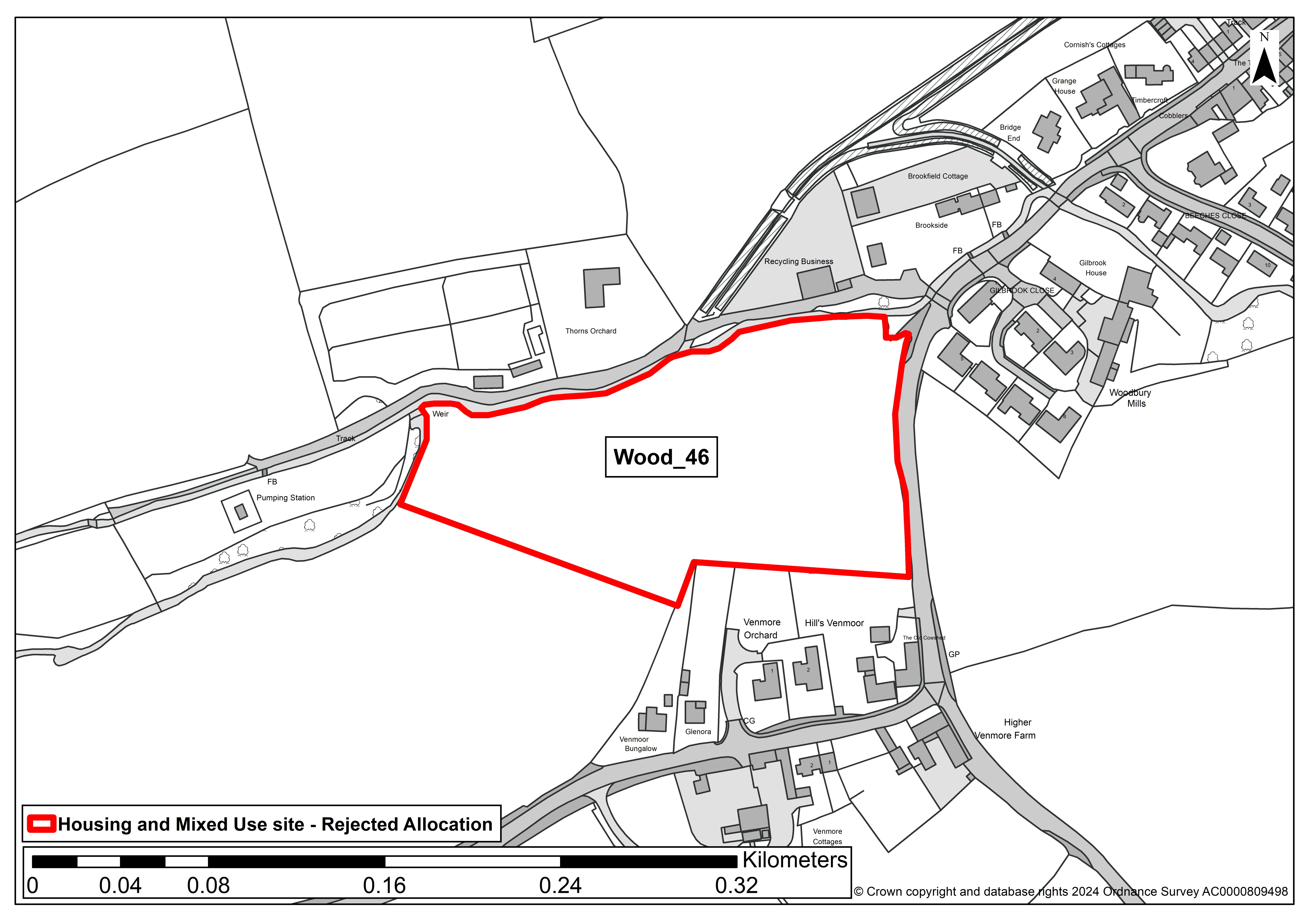
SITE ASSESSMENT SUMMARY AND CONCLUSION
Infrastructure
No Devon County Council Education or Highways comments specifically for this site, but education capacity issues are highlighted for other sites in Woodbury, and comments for Wood_10 across the road identify need for continuous footway to connect to adjoining site - the public right of way just beyond the northern edge of Wood_46 offers the opportunity for a continuous footway that avoids the main road, although this would require a bridge over the intervening stream.
The middle and outer zones associated with the high pressure gas pipeline cover the western part of the site.
Landscape
Located within Landscape Character Type E. Lowland plains.
Large, level, arable field adjoining the western tip of Woodbury. Open, short distance views of the site from the public right of way to the north of the site.
The site protrudes into open countryside, with limited context of built form. Overall, a medium/high landscape sensitivity.
Historic environment
Woodbury Conservation Area 30m to NE but intervening trees mean limited intervisibility. 2 Grade II listed buildings 90m to east and 65m to south, but intervening dwellings mean no adverse impact upon these assets.
Overall, Low - no concerns identified on current evidence, although archaeological mitigation measures may be required.
Ecology
A single arable field, with a stream running along the northern boundary and small group of trees to NE and NW. Minor adverse effect predicted (not significant).
Accessibility
Ten out of 12 facilities within 1,600m, but currently the site does not link to existing footpaths.
The public right of way just beyond the northern edge of the site offers the opportunity for a continuous footway that avoids the main road, which would require a bridge over the intervening stream.
Other constraints
Grade 3 agricultural land. Flood Zone 3 covers northern part of site, overlapping with surface water flood risk, so net area of 0.95 ha and yield reduced accordingly.
Flood Zone 2 extends further across the site, leaving around 0.44 ha in Flood Zone 1.
Within Green Wedge in adopted Local Plan 2013-31 or made Neighbourhood Plan?
No
Opportunities
Upgrade the public right of way to provide a pedestrian route that connects to the existing footpath into the settlement centre, including a footbridge from the site over the stream.
Yield (number of dwellings)
23
Contribution to spatial strategy
The spatial strategy identifies Woodbury as a Local Centre to meet local development needs and those of immediate surrounds.
Whilst the site in isolation accords with this strategy, there are other more preferable sites in Woodbury to meet this strategy.
Should the site be allocated?
No
Reasons for allocating or not allocating
Medium/high landscape impact, poorly related to the existing built form in Woodbury.
Whilst the site in isolation accords with the spatial strategy, there are other more preferable sites in Woodbury to meet this strategy.
If whole site is not suitable for allocation, could a smaller part be allocated?
No
Beer_03
SITE DETAILS
Settlement: Beer
Reference number: Beer_03
Site area (ha): 1.23
Address: Land at Quarry Lane, Beer
Proposed use: Residential
SITE MAP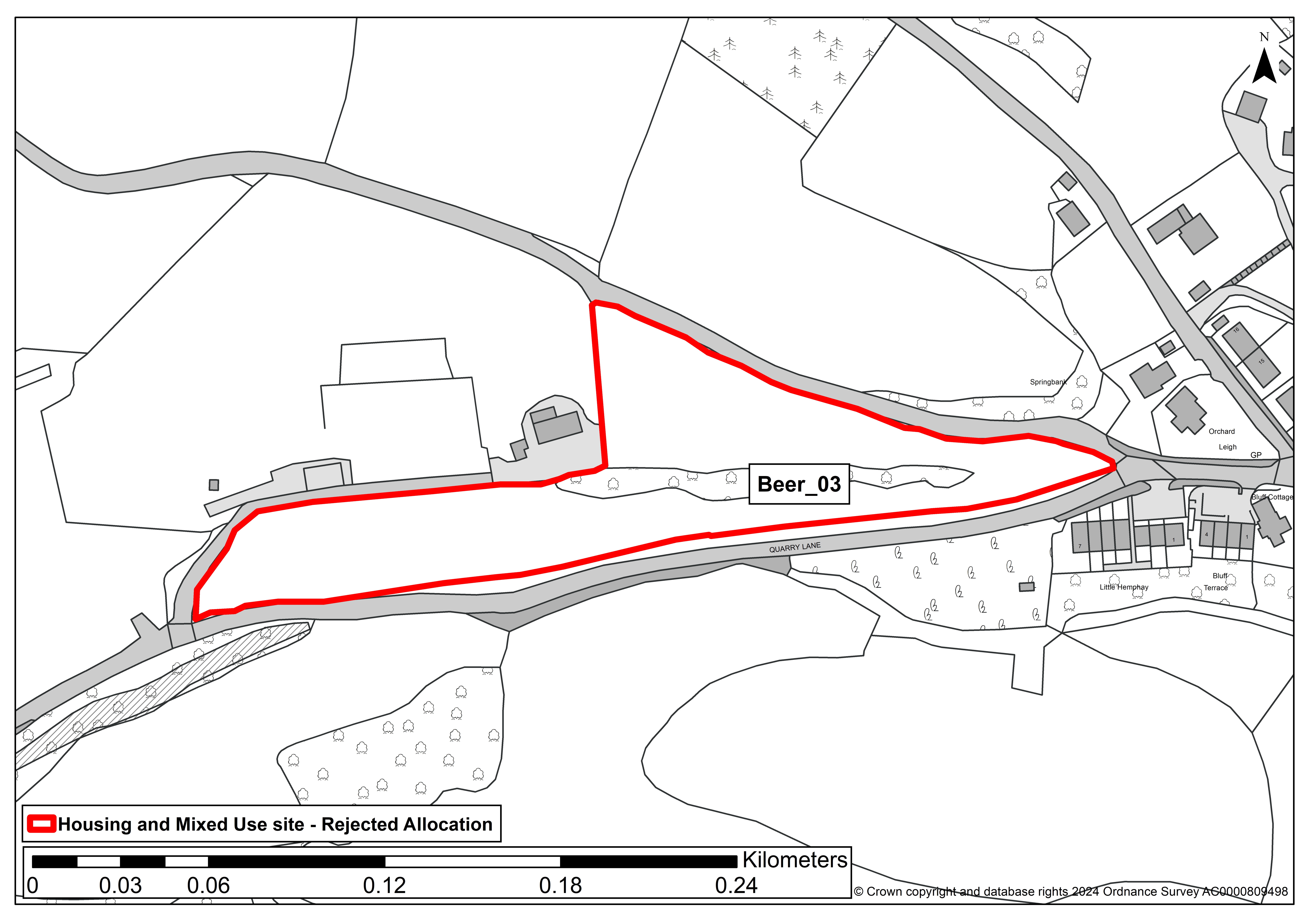
SITE ASSESSMENT SUMMARY AND CONCLUSION
Infrastructure
Site is adjacent to Quarry Lane and is assessible by pavement from the centre of Beer. Comments of the Highway Authority regarding creation of access onto Quarry Lane not yet available.
The Education Authority advise that Beer Primary school has limited capacity to support development and lies on a very constrained site, and also that there would be a transport implication for access to the nearest secondary school.
Landscape
Sensitivity is considered to be high. The site lies entirely within the East Devon National Landscape and the Coastal Preservation Area, just beyond the far extent of built development at Beer along Quarry Lane.
The site forms part of the setting and approach to Beer at this point, and has an intact tranquil and rural character (typical of the landscape character type for the area). It is considered to have a high scenic quality, with few modern detractors visible.
Historic environment
There are no designated heritage assets within 100m of the site. The site lies c.200m from the far eastern extremity of the Beer Conservation Area which covers the historic centre of Beer, and c.230m from the nearest Listed Building within it, with intervening modern / new residential development.
Whilst there is no direct intervisibility, the site forms part of the setting of Beer and has a sense of being part of an historic landscape due to the enclosed pastoral nature of it.
Lying on Quarry Lane, c.230m from the former stone quarry, there is also a cultural/heritage association with the quarrying industry which has shaped the development of Beer.
There is possible archaeological interest lying within any artefacts scattered adjacent to a lithic working site.
Overall, heritage impact is assessed as medium where there are no significant impacts that could not be mitigated.
Ecology
Site comprises pasture/scrub and mature boundary hedgerows/hedgebanks and trees. Beer Quarry and Caves Special Area for Conservation and Site of Special Scientific Interest lies in close proximity (c220m) to the west and in an area used by foraging bats, within the Consultation, Sustenance and Landscape Connectivity Zones.
Also lies within 100m of Bovey Lane Fields County Wildlife Site (species-rich unimproved grassland) and opposite (across Quarry Lane) from areas identified on both priority habitat inventory and as nature recovery network, comprising 'additional' (no main) habitat, interspersed with areas of deciduous woodland/forest.
No designations within/overlapping the site. At this stage, significant moderate adverse impact predicted.
Accessibility
The site includes nine community facilities and services within 1,600m. This includes an hourly or better bus service, primary school, convenience shop(s), post office, community hall, pub(s), open space/allotment, GP and children's play area.
There is limited capacity at the primary school however as noted by the Local Education Authority.
The majority of these facilities are within the village centre to which there is a direct safe walking route on pavements from immediately opposite the easternmost end of the site.
Other constraints
Although the site frontage along Quarry Lane is relatively flat, there is steep topography within the site, with gradients as steep as 1:3.
The site is not within but close to an area of floodzone 2/3; it is not subject to surface water flooding.
It is within a drinking water source protection zone 2 and Mineral Consultation Area. The site comprises Grade 3 agricultural land, which may include best and most versatile land (3a).
Within Green Wedge in adopted Local Plan 2013-31 or made Neighbourhood Plan?
No
Opportunities
None identified.
Yield (number of dwellings)
35
Contribution to spatial strategy
Delivering this site would be consistent with the spatial strategy for Beer as a Service Village to allow limited development to meet local needs.
Should the site be allocated?
No
Reasons for allocating or not allocating
Primarily for reasons of landscape impact and intrusion in to the countryside, combined with heritage and ecology concerns.
If whole site is not suitable for allocation, could a smaller part be allocated?
No, it is unlikely that a reduced area would overcome the issues identified.
Plym_05
SITE DETAILS
Settlement: Plymtree
Reference number: Plym_05
Site area (ha): 3.29
Address: Land West of the Village Hall
Proposed use: Residential
SITE MAP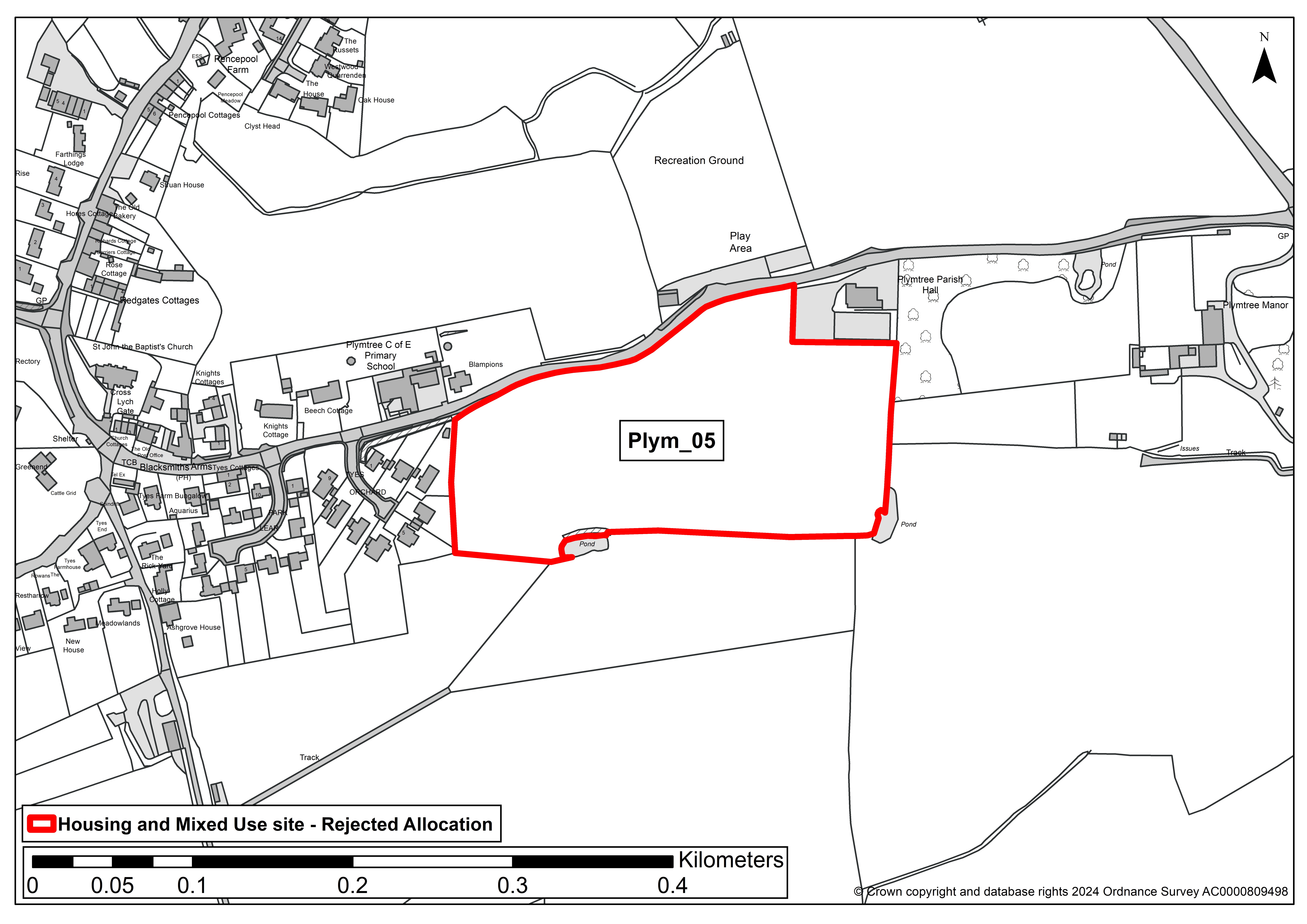
SITE ASSESSMENT SUMMARY AND CONCLUSION
Infrastructure
Plymtree Primary has some capacity to support development, but not to accommodate all of the potential development. Transport costs to the secondary school would apply
Landscape
Medium sensitivity - Existing development on one side provides some context of built form, and the presence of mature hedgerows and trees lessen visibility over parts of the site.
However the site has a close relationship with surrounding countryside.
Historic environment
Medium sensitivity - No significant effects which cannot be mitigated. An impact is predicted, but would not compromise the asset(s) cultural heritage value to the extent that the attributes that led to its designation, or ability to understand or appreciate its value, are diminished or compromised.
Mitigation may make the impact acceptable, this is likely to be in the form. The overall significance of the asset would not therefore be materially changed.
Ecology
Minor adverse effect predicted (not significant)
Accessibility
The site is within 1,600 metres of four or more different local facilities but over 1,600 metres from a train station or bus route with an hourly or better service
Other constraints
None identified
Within Green Wedge in adopted Local Plan 2013-31 or made Neighbourhood Plan?
No
Opportunities
None identified
Yield (number of dwellings)
43
Contribution to spatial strategy
Plymtree is a service village in the emerging Local Plan settlement hierarchy.
Should the site be allocated?
No
Reasons for allocating or not allocating
The site is a significant greenfield site which contributes to the setting of the adjacent listed Manor House and it's formal gardens.
It is located on the periphery of the village (albeit the village hall is located beyond it) and would extend built form into the open countryside.
If whole site is not suitable for allocation, could a smaller part be allocated?
No
Otry_22
SITE DETAILS
Settlement: Tipton St John
Reference number: Otry_22
Site area (ha): 0.97
Address: Combe Bank
Proposed use: Residential
SITE MAP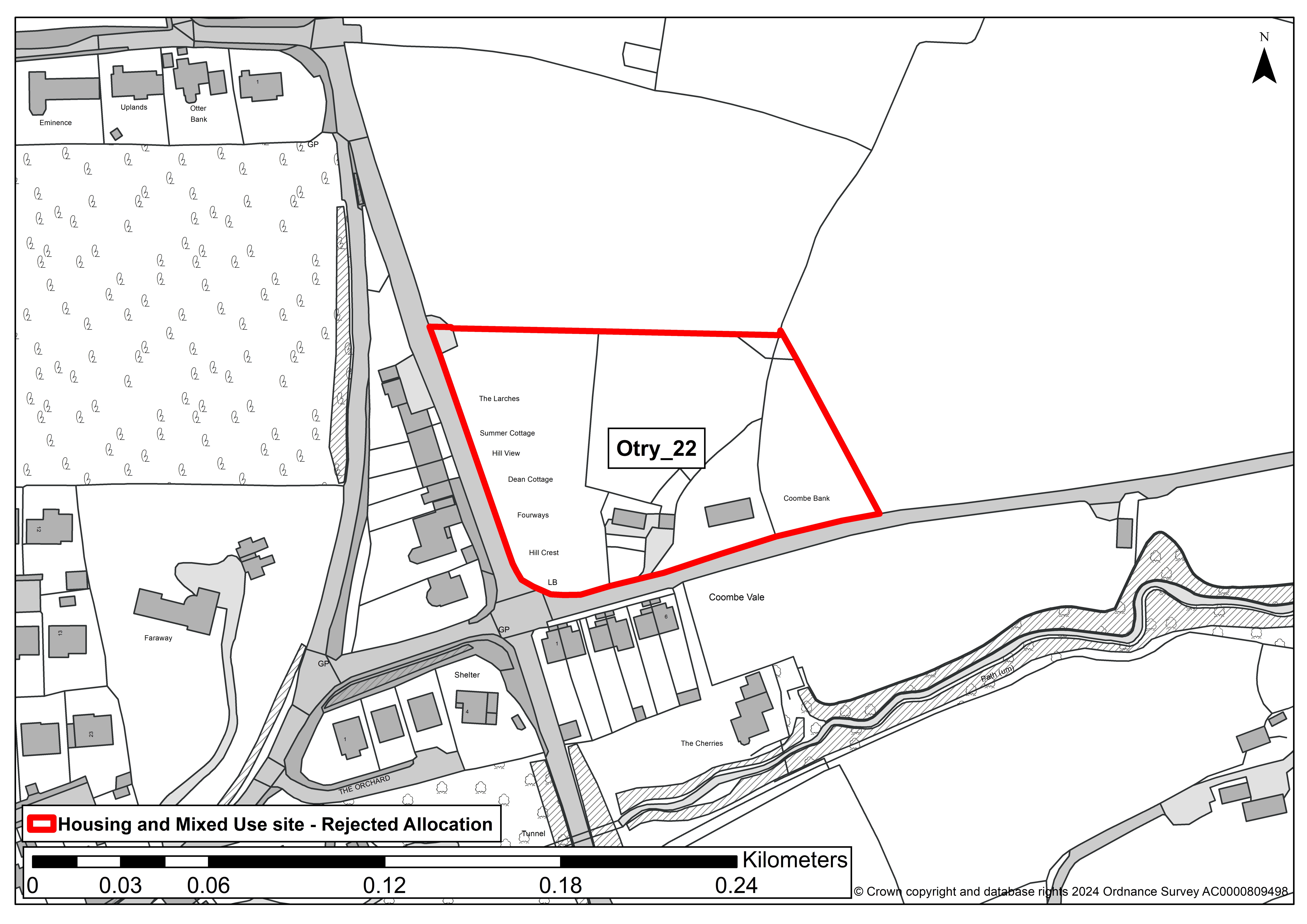
SITE ASSESSMENT SUMMARY AND CONCLUSION
Infrastructure
This site can be accessed via the 'main' road, with the 30mph speed limit extended. Concerns as the current Tipton St John primary school buildings are located in the floodplain.
Devon County Council are trying to find a site to relocate the school out of the floodplain. Currently the majority of children come from Sidmouth or Ottery St Mary - so development could lead to a push back to these schools which have limited capacity.
Any significant development within the village should consider the requirement for a new primary school site.
Additional secondary capacity required and transport costs would apply. The Kings School academy has previously clearly indicated it will not expand unless with significant investment and potentially new school buildings.
Landscape
Medium-High sensitivity - An enclosed site, surrounded by hedgerows on most sides. Topography and sloping site mean that the site sits higher than the adjoining road and development is therefore likely to be more visible.
Long range intervisibility from the AONB to the south-east is likely. New road access is needed, so a hedgerow would need to be removed and this would open the site up to views from the road. Long distance views of hills looking out from the site.
Historic environment
Low sensitivity - No concerns identified on current evidence, although archaeological mitigation measures may be required. No impact upon an asset is predicted or, if an impact is predicted, the cultural heritage value of the asset(s) would be unaffected.
Ecology
Minor adverse effect predicted (not significant)
Accessibility
The site is within 1,600m of four or more facilities including a school (although this is proposed to be relocated outside the village), a hall, a pub and a shop. There is not a regular bus service.
Other constraints
None identified
Within Green Wedge in adopted Local Plan 2013-31 or made Neighbourhood Plan?
No
Opportunities
None identified
Yield (number of dwellings)
29
Contribution to spatial strategy
Tipton St John is a service village in the emerging Local Plan settlement hierarchy, however it will lose this status if the school closes
Should the site be allocated?
No
Reasons for allocating or not allocating
The site is a greenfield site which would extend into open countryside. There is no other development on this side of the road.
Development would be visible from a considerable distance and negatively impact the National Landscape.
If whole site is not suitable for allocation, could a smaller part be allocated?
No
This engagement phase has finished

...